
Carte topographique Mount Hood
Carte interactive
Cliquez sur la carte pour afficher l’altitude.
À propos de cette carte
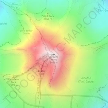
Nom : Carte topographique Mount Hood, altitude, relief.
Lieu : Mount Hood, Hood River County, Oregon, United States (45.37346 -121.69593 45.37356 -121.69583)
Altitude moyenne : 2’716 m
Altitude minimum : 2’213 m
Altitude maximum : 3’416 m
Timberline Lodge is a National Historic Landmark located on the southern flank of Mount Hood just below Palmer Glacier, with an elevation of about 6,000 ft (1,800 m).
Autres cartes topographiques
Cliquez sur une carte pour visualiser sa topographie, son altitude et son relief.
Hood River
United States > Oregon > Hood River County
Hood River, Hood River County, Oregon, United States
Altitude moyenne : 112 m
Parkdale
United States > Oregon > Hood River County > Parkdale
Parkdale, Hood River County, Oregon, United States
Altitude moyenne : 538 m
Odell
United States > Oregon > Hood River County
Odell, Hood River County, Oregon, United States
Altitude moyenne : 244 m
Badger Lake Dam
United States > Oregon > Hood River County
Badger Lake Dam, Hood River County, Oregon, United States
Altitude moyenne : 1’565 m
Government Cove
United States > Oregon > Hood River County > Cascade Locks
Government Cove, Cascade Locks, Hood River County, Oregon, United States
Altitude moyenne : 89 m
Cascade Locks Marine Park
United States > Oregon > Hood River County > Cascade Locks
Cascade Locks Marine Park, Cascade Locks, Hood River County, Oregon, United States
Altitude moyenne : 72 m
Dee
United States > Oregon > Hood River County
Dee, Hood River County, Oregon, United States
Altitude moyenne : 424 m
Columbia River
United States > Oregon > Hood River County > Cascade Locks
Columbia River, Cascade Locks, Hood River County, Oregon, United States
Altitude moyenne : 543 m
Cascade Locks
United States > Oregon > Hood River County
Cascade Locks, Hood River County, Oregon, United States
Altitude moyenne : 101 m
Shellrock Spring
United States > Oregon > Hood River County
Shellrock Spring, Forest Road 17, Hood River County, Oregon, United States
Altitude moyenne : 1’157 m