Carte topographique Alva
Carte interactive
Cliquez sur la carte pour afficher l’altitude.
À propos de cette carte
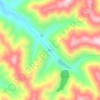
Nom : Carte topographique Alva, altitude, relief.
Lieu : Alva, Harlan County, Kentucky, 40863, United States (36.71509 -83.44435 36.75509 -83.40435)
Altitude moyenne : 652 m
Altitude minimum : 389 m
Altitude maximum : 922 m
Autres cartes topographiques
Cliquez sur une carte pour visualiser sa topographie, son altitude et son relief.
Pine Mountain
United States > Kentucky > Harlan County
Pine Mountain, Harlan County, Kentucky, United States
Altitude moyenne : 536 m
Pathfork
United States > Kentucky > Harlan County
Pathfork, Harlan County, Kentucky, 40863, United States
Altitude moyenne : 534 m
Lenarue
United States > Kentucky > Harlan County
Lenarue, Harlan County, Kentucky, 40818, United States
Altitude moyenne : 519 m
Bardo
United States > Kentucky > Harlan County
Bardo, Harlan County, Kentucky, 40830, United States
Altitude moyenne : 634 m
Holmes Mill
United States > Kentucky > Harlan County
Holmes Mill, Harlan County, Kentucky, 40843, United States
Altitude moyenne : 758 m
Pansy
United States > Kentucky > Harlan County
Pansy, Harlan County, Kentucky, 40830, United States
Altitude moyenne : 602 m
Putney
United States > Kentucky > Harlan County
Putney, Harlan County, Kentucky, 40865, United States
Altitude moyenne : 601 m
Yancey
United States > Kentucky > Harlan County
Yancey, Harlan County, Kentucky, 40830, United States
Altitude moyenne : 651 m
Fresh Meadows
United States > Kentucky > Harlan County
Fresh Meadows, Harlan County, Kentucky, 40824, United States
Altitude moyenne : 462 m
Lejunior
United States > Kentucky > Harlan County
Lejunior, Harlan County, Kentucky, 40865, United States
Altitude moyenne : 585 m
Three Point
United States > Kentucky > Harlan County
Three Point, Harlan County, Kentucky, 40815, United States
Altitude moyenne : 475 m
Kenvir
United States > Kentucky > Harlan County
Kenvir, Harlan County, Kentucky, 40847, United States
Altitude moyenne : 642 m
Ages
United States > Kentucky > Harlan County
Ages, Harlan County, Kentucky, 40801, United States
Altitude moyenne : 587 m
Wallins Creek
United States > Kentucky > Harlan County
Wallins Creek, Harlan County, Kentucky, United States
Altitude moyenne : 416 m
Louellen
United States > Kentucky > Harlan County
Louellen, Harlan County, Kentucky, 40849, United States
Altitude moyenne : 698 m
Big Laurel
United States > Kentucky > Harlan County
Big Laurel, Harlan County, Kentucky, 40808, United States
Altitude moyenne : 574 m
Cawood
United States > Kentucky > Harlan County
Cawood, Harlan County, Kentucky, 40818, United States
Altitude moyenne : 498 m
South Wallins
United States > Kentucky > Harlan County > South Wallins
South Wallins, Harlan County, Kentucky, 40873, United States
Altitude moyenne : 528 m
Dayhoit
United States > Kentucky > Harlan County
Dayhoit, Harlan County, Kentucky, 40824, United States
Altitude moyenne : 462 m
Loyall
United States > Kentucky > Harlan County
Loyall, Harlan County, Kentucky, 40854, United States
Altitude moyenne : 434 m
Molus
United States > Kentucky > Harlan County
Molus, Harlan County, Kentucky, 40819, United States
Altitude moyenne : 467 m
Closplint
United States > Kentucky > Harlan County
Closplint, Harlan County, Kentucky, 40927, United States
Altitude moyenne : 716 m
Benham
United States > Kentucky > Harlan County
Benham, Harlan County, Kentucky, 40807, United States
Altitude moyenne : 667 m
Totz
United States > Kentucky > Harlan County
Totz, Harlan County, Kentucky, 40870, United States
Altitude moyenne : 638 m
Bledsoe
United States > Kentucky > Harlan County
Bledsoe, Harlan County, Kentucky, 40810, United States
Altitude moyenne : 604 m
Creech
United States > Kentucky > Harlan County
Creech, Harlan County, Kentucky, United States
Altitude moyenne : 661 m
River Ridge
United States > Kentucky > Harlan County
River Ridge, Harlan County, Kentucky, 40828, United States
Altitude moyenne : 584 m
Evarts
United States > Kentucky > Harlan County
Evarts, Harlan County, Kentucky, United States
Altitude moyenne : 533 m
Baxter
United States > Kentucky > Harlan County
Baxter, Harlan County, Kentucky, 40806, United States
Altitude moyenne : 468 m
Coldiron
United States > Kentucky > Harlan County
Coldiron, Harlan County, Kentucky, 40819, United States
Altitude moyenne : 472 m
Lynch
United States > Kentucky > Harlan County
Lynch, Harlan County, Kentucky, United States
Altitude moyenne : 770 m
Divide
United States > Kentucky > Harlan County
Divide, Harlan County, Kentucky, 40865, United States
Altitude moyenne : 657 m
Cranks
United States > Kentucky > Harlan County
Cranks, Harlan County, Kentucky, 40820, United States
Altitude moyenne : 594 m
Harlan
United States > Kentucky > Harlan County
Harlan, Harlan County, Kentucky, 40831, United States
Altitude moyenne : 493 m
Harlan
United States > Kentucky > Harlan County > Harlan > Harlan
Harlan, Harlan County, Kentucky, 40831, United States
Altitude moyenne : 512 m
Cumberland
United States > Kentucky > Harlan County
Cumberland, Harlan County, Kentucky, 40823, United States
Altitude moyenne : 591 m