
Faire un don
Équipez-vous pour votre prochaine aventure :
En tant que Partenaire Amazon, ce site perçoit une commission sur les achats éligibles sans surcoût pour vous.
Carte topographique Bhimtal
Cliquez sur la carte pour afficher l’altitude.
Faire un don
Équipez-vous pour votre prochaine aventure :
En tant que Partenaire Amazon, ce site perçoit une commission sur les achats éligibles sans surcoût pour vous.
À propos de cette carte
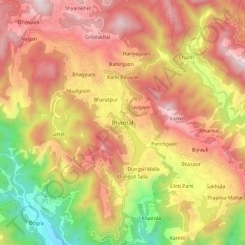
Nom : Carte topographique Bhimtal, altitude, relief.
Lieu : Bhimtal, Nainital, Uttarakhand, 263136, India (29.31061 79.51417 29.39061 79.59417)
Altitude moyenne : 1’386 m
Altitude minimum : 634 m
Altitude maximum : 1’973 m
Faire un don
Équipez-vous pour votre prochaine aventure :
En tant que Partenaire Amazon, ce site perçoit une commission sur les achats éligibles sans surcoût pour vous.
Autres cartes topographiques
Cliquez sur une carte pour visualiser sa topographie, son altitude et son relief.
Nainital
India > Uttarakhand > Nainital
Nainital is located in the Kumaon foothills of the outer Himalayas at a distance of 276 km (171 mi) from the state capital Dehradun and 314 km (195 mi) from New Delhi, the capital of India. Situated at an altitude of 1,938 metres (6,358 ft) above sea level, the town is set in a valley containing an eye-shaped…
Altitude moyenne : 2’059 m
Faire un don
Équipez-vous pour votre prochaine aventure :
En tant que Partenaire Amazon, ce site perçoit une commission sur les achats éligibles sans surcoût pour vous.
Nainital
India > Uttarakhand > Nainital
Nainital is located in the Kumaon foothills of the outer Himalayas at a distance of 276 km (171 mi) from the state capital Dehradun and 314 km (195 mi) from New Delhi, the capital of India. Situated at an altitude of 1,938 metres (6,358 ft) above sea level, the town is set in a valley containing an eye-shaped…
Altitude moyenne : 2’059 m