Géolocaliser

Carte topographique Nainital

Carte interactive

Cliquez sur la carte pour afficher l’altitude.

À propos de cette carte

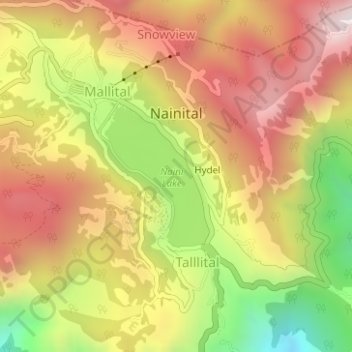
Nom : Carte topographique Nainital, altitude, relief.

Lieu : Nainital, Nainital District, Uttarakhand, 263003, India (29.37263 79.43883 29.39879 79.46999)

Altitude moyenne : 2’059 m

Altitude minimum : 1’562 m

Altitude maximum : 2’449 m

Nainital is located in the Kumaon foothills of the outer Himalayas at a distance of 276 km (171 mi) from the state capital Dehradun and 314 km (195 mi) from New Delhi, the capital of India. Situated at an altitude of 1,938 metres (6,358 ft) above sea level, the town is set in a valley containing an eye-shaped lake, approximately two miles in circumference, and surrounded by mountains, of which the highest are Naina Peak (2,615 m (8,579 ft)) on the north, Deopatha (2,438 m (7,999 ft)) on the west, and Ayarpatha (2,278 m (7,474 ft)) on the south. From the tops of the higher peaks, "magnificent views can be obtained of the vast plain to the south, or of the mass of tangled ridges lying north, bound by the great snowy range which forms the central axis of the Himalayas." The hill station attracts tourists round the year.

Wikipedia (CC-BY-SA 3.0)

Autres cartes topographiques

Cliquez sur une carte pour visualiser sa topographie, son altitude et son relief.

Khopi

India > Uttarakhand > Nainital > Bhumiyadhar

Khopi, Bhumiyadhar, Nainital, Nainital District, Uttarakhand, 263003, India

Altitude moyenne : 1’656 m

Naini Lake

India > Uttarakhand > Nainital > Nainital

Naini Lake, Talllital, Nainital, Nainital District, Uttarakhand, India

Altitude moyenne : 2’057 m

Kuleti

India > Uttarakhand > Nainital

Kuleti, Nainital, Nainital District, Uttarakhand, India

Altitude moyenne : 1’927 m

Hariyal

India > Uttarakhand > Nainital

Hariyal, Nainital, Nainital District, Uttarakhand, India

Altitude moyenne : 1’818 m

Maneri

India > Uttarakhand > Nainital

Maneri, Nainital, Nainital District, Uttarakhand, 236002, India

Altitude moyenne : 1’594 m

Bilaspur

India > Uttarakhand > Nainital

Bilaspur, Nainital, Uttarakhand, 263136, India

Altitude moyenne : 1’377 m

Sariya

India > Uttarakhand > Nainital > Char Khet

Sariya, Char Khet, Nainital, Uttarakhand, 263002, India

Altitude moyenne : 1’818 m

Bhimtal

India > Uttarakhand > Nainital

Bhimtal, Nainital, Uttarakhand, 263136, India

Altitude moyenne : 1’458 m

Bhowali

India > Uttarakhand > Nainital

Bhowali, Nainital, Uttarakhand, 263136, India

Altitude moyenne : 1’663 m