
Faire un don
Équipez-vous pour votre prochaine aventure :
En tant que Partenaire Amazon, ce site perçoit une commission sur les achats éligibles sans surcoût pour vous.
Carte topographique Benital
Cliquez sur la carte pour afficher l’altitude.
Faire un don
Équipez-vous pour votre prochaine aventure :
En tant que Partenaire Amazon, ce site perçoit une commission sur les achats éligibles sans surcoût pour vous.
À propos de cette carte
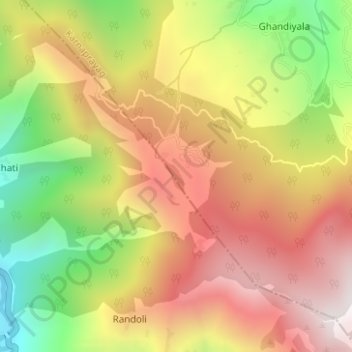
Nom : Carte topographique Benital, altitude, relief.
Lieu : Benital, Karnaprayag, Chamoli, Uttarakhand, India (30.15919 79.24506 30.16172 79.24692)
Altitude moyenne : 1’850 m
Altitude minimum : 1’238 m
Altitude maximum : 2’362 m
Faire un don
Équipez-vous pour votre prochaine aventure :
En tant que Partenaire Amazon, ce site perçoit une commission sur les achats éligibles sans surcoût pour vous.
Autres cartes topographiques
Cliquez sur une carte pour visualiser sa topographie, son altitude et son relief.
Gauchar
India > Uttarakhand > Karnaprayag
Gauchar (Garhwali: Gòchàr ) is a Hill Town sort of a valley town located in Karnaprayag tehsil within Chamoli district of Uttarakhand state in India. Gauchar is situated on the left bank of river Alaknanda and is en route to the celebrated holy destination of Badrinath. It is well known for being one of the…
Altitude moyenne : 1’196 m
Karnaprayag
India > Uttarakhand > Karnaprayag
Karnaprayag is located at 30°16′N 79°15′E / 30.27°N 79.25°E / 30.27; 79.25. It has an average elevation of 860 metres (2,820 feet). The confluence of the Pindar River, which arises from the icy Pindari glacier and the Alaknanda, occurs at Karnaprayag.
Altitude moyenne : 1’273 m
Faire un don
Équipez-vous pour votre prochaine aventure :
En tant que Partenaire Amazon, ce site perçoit une commission sur les achats éligibles sans surcoût pour vous.
Gauchar
India > Uttarakhand > Karnaprayag
Gauchar (Garhwali: Gòchàr ) is a Hill Town sort of a valley town located in Karnaprayag tehsil within Chamoli district of Uttarakhand state in India. Gauchar is situated on the left bank of river Alaknanda and is en route to the celebrated holy destination of Badrinath. It is well known for being one of the…
Altitude moyenne : 1’196 m
Gauchar
India > Uttarakhand > Karnaprayag
Gauchar (Garhwali: Gòchàr ) is a hill town located in Karnaprayag tehsil subdistrict within Chamoli district of Uttarakhand state in India. Gauchar is situated on the left bank of river Alaknanda and is en route to the celebrated holy destination of Badrinath. Situated at an altitude of 800 metres (2,620 ft)…
Altitude moyenne : 1’196 m
Faire un don
Équipez-vous pour votre prochaine aventure :
En tant que Partenaire Amazon, ce site perçoit une commission sur les achats éligibles sans surcoût pour vous.