
Carte topographique Karnaprayag
Cliquez sur la carte pour afficher l’altitude.
Karnaprayag
Karnaprayag is located at 30°16′N 79°15′E / 30.27°N 79.25°E / 30.27; 79.25. It has an average elevation of 860 metres (2,820 feet). The confluence of the Pindar River, which arises from the icy Pindari glacier and the Alaknanda, occurs at Karnaprayag.
À propos de cette carte
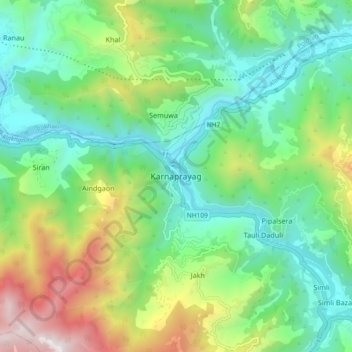
Nom : Carte topographique Karnaprayag, altitude, relief.
Lieu : Karnaprayag, Chamoli, Uttarakhand, 246444, India (30.21965 79.17707 30.29965 79.25707)
Altitude moyenne : 1’273 m
Altitude minimum : 714 m
Altitude maximum : 2’536 m
Autres cartes topographiques
Cliquez sur une carte pour visualiser sa topographie, son altitude et son relief.