
Carte topographique Burnet
Cliquez sur la carte pour afficher l’altitude.
À propos de cette carte
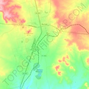
Nom : Carte topographique Burnet, altitude, relief.
Lieu : Burnet, Burnet County, Texas, 78611, United States (30.69130 -98.27983 30.78552 -98.16564)
Altitude moyenne : 404 m
Altitude minimum : 334 m
Altitude maximum : 491 m
Autres cartes topographiques
Cliquez sur une carte pour visualiser sa topographie, son altitude et son relief.
Inks Lake State Park
United States > Texas > Burnet County > Burnet
Conservation Pool Elevation usually stays around 888.22 ft. msl; however, this lake does fluctuate about 1 foot annually. Inks lake water clarity can be seen as clear to slightly stained mostly throughout the year. It tends to have higher turbidity during the rainy season due to excessive amounts of runoff.
Altitude moyenne : 294 m
Briggs
United States > Texas > Burnet County
Briggs lies along U.S. Route 183 and FM 2657, northeast of Burnet. Its elevation is 1,102 feet (336 m), and it is located at 30°53′23″N 97°55′30″W / 30.88972°N 97.92500°W / 30.88972; -97.92500. Although Briggs is unincorporated, it has a post office, with the ZIP code of 78608. The…
Altitude moyenne : 336 m
Marble Falls
United States > Texas > Burnet County > Marble Falls > Marble Falls
Altitude moyenne : 261 m