
Carte topographique Royston
Cliquez sur la carte pour afficher l’altitude.
Royston
Royston lies on the Barnsley Canal, and on the intersection of the B6132 and B6428 roads, due north of Monk Bretton at an elevation of around 246 feet (75 m) above sea level. The Trans Pennine Trail runs through Royston along the canal bank. The parish is part of the diocese of Leeds.
À propos de cette carte
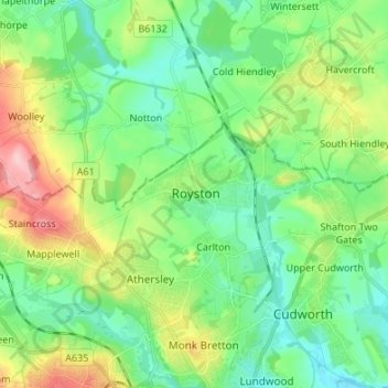
Nom : Carte topographique Royston, altitude, relief.
Altitude moyenne : 74 m
Altitude minimum : 31 m
Altitude maximum : 173 m
Autres cartes topographiques
Cliquez sur une carte pour visualiser sa topographie, son altitude et son relief.
Sheffield
Sheffield nestles on the eastern foothills of the Pennines and is sculpted by a dramatic hill-and-valley system formed where five rivers — the Don, Sheaf, Rivelin, Loxley and Porter — converge, producing steep-sided valleys and gritstone ridgelines with much of the urban area built directly onto hillsides…
Altitude moyenne : 168 m
Birmingham
Birmingham is a snowy city relative to other large UK conurbations, due to its inland location and comparatively high elevation. Between 1961 and 1990 Birmingham Airport averaged 13.0 days of snow lying annually, compared to 5.33 at London Heathrow. Snow showers often pass through the city via the Cheshire gap…
Altitude moyenne : 138 m
East of England
The East of England region has the lowest elevation range in the UK. Twenty percent of the region is below mean sea level, most of this in North Cambridgeshire, Norfolk and on the Essex Coast. Most of the remaining area is of low elevation, with extensive glacial deposits. The Fens, a large area of reclaimed…
Altitude moyenne : 39 m
South East England
Near Weybridge are the UK headquarters of Sony with SSP Group (situated in Byfleet) and Procter & Gamble (next door to each other on The Heights Business Park near the former Brooklands racing circuit) with Kia Motors UK and Petroleum Geo-Services UK, and Gallaher Group (cigarettes) is to the north, next to…
Altitude moyenne : 69 m
Cornwall
The interior of the county consists of a roughly east–west spine of infertile and exposed upland, with a series of granite intrusions, such as Bodmin Moor, which contains the highest land within Cornwall. From east to west, and with approximately descending altitude, these are Bodmin Moor, Hensbarrow north…
Altitude moyenne : 55 m
Exeter
United Kingdom > England > Devon
The city of Exeter was established on the eastern bank of the River Exe on a ridge of land backed by a steep hill. It is at this point that the Exe, having just been joined by the River Creedy, opens onto a wide flood plain and estuary which results in quite common flooding. Historically this was the lowest…
Altitude moyenne : 56 m
Kent
Kent was also the location of the largest number of art schools in the country during the nineteenth century, estimated by the art historian David Haste, to approach two hundred. This is believed to be the result of Kent being a front line county during the Napoleonic Wars. At this time, before the invention…
Altitude moyenne : 37 m
Bath
United Kingdom > England > Bath and North East Somerset
Bath is in the Avon Valley and is surrounded by limestone hills as it is near the southern edge of the Cotswolds, a designated Area of Outstanding Natural Beauty, and the limestone Mendip Hills rise around 7 miles (11 km) south of the city. The hills that surround and make up the city have a maximum altitude…
Altitude moyenne : 100 m
Lake District National Park
The Lake District is a roughly circular upland massif, deeply dissected by a broadly radial pattern of major valleys which are largely the result of repeated glaciations over the last 2 million years. The apparent radial pattern is not from a central dome, but from an axial watershed extending from St Bees…
Altitude moyenne : 206 m
Greater London
London's topography is characterized by a gently rolling terrain shaped by the River Thames and its tributaries. The city lies within the London Basin, a natural depression bordered by higher grounds such as the North Downs to the south and the Chiltern Hills to the northwest. The Thames flows west to east,…
Altitude moyenne : 66 m
Surrey
United Kingdom > England > Surrey
The highest elevation in Surrey is Leith Hill near Dorking. It is 295 m (968 ft) above sea level and is the second highest point in southeastern England after Walbury Hill in West Berkshire which is 297 m (974 ft).
Altitude moyenne : 69 m
Cambridge
United Kingdom > England > Cambridge
The city, like most of the UK, has a maritime climate highly influenced by the Gulf Stream. Located in the driest region of Britain, Cambridge's rainfall averages around 570 mm (22.44 in) per year, around half the national average, with some years occasionally falling into the semi-arid (under 500 mm (19.69…
Altitude moyenne : 18 m
Yorkshire
In Yorkshire there is a very close relationship between the major topographical areas and the geological period in which they were formed. The Pennine chain of hills in the west is of Carboniferous origin. The central vale is Permo-Triassic. The North York Moors in the north-east of the county are Jurassic in…
Altitude moyenne : 130 m
Dartmoor National Park
United Kingdom > England > Devon
Rainfall tends to be associated with Atlantic depressions or with convection. In summer, convection caused by solar surface heating sometimes forms shower clouds and a large proportion of rainfall falls from showers and thunderstorms at this time of year. The wettest months are November and December and on the…
Altitude moyenne : 239 m
Harrogate
United Kingdom > England > North Yorkshire
Harrogate is situated on the edge of the Yorkshire Dales, with the Vale of York to the east and the upland Yorkshire Dales to the west and north-west. It has a dry and mild climate, typical of places in the rain shadow of the Pennines. It is on the A59 from Skipton to York. At an altitude of between 100 and…
Altitude moyenne : 131 m
Woodsetts
United Kingdom > England > Rotherham
Woodsetts is a village and civil parish in the Metropolitan Borough of Rotherham in South Yorkshire, England, on the border with Nottinghamshire. It lies between the towns of Dinnington and Worksop at an elevation of around 60 metres above sea level, and has a population of 1,746 at the 2011 Census. The…
Altitude moyenne : 70 m
Chilterns National Landscape
United Kingdom > England > Buckinghamshire
The highest point is at 267 m (876 ft.) above sea level at Haddington Hill near Wendover in Buckinghamshire; a stone monument marks the summit. The nearby Ivinghoe Beacon is a more prominent hill, although its altitude is only 249 m (817 ft.). It is the starting point of the Icknield Way Path and the Ridgeway…
Altitude moyenne : 102 m
Romney, Hythe and Dymchurch Railway
United Kingdom > England > Kent > Folkestone and Hythe > St. Mary in the Marsh
Altitude moyenne : 1 m
Cambridge
United Kingdom > England > Cambridgeshire
The city, like most of the UK, has a maritime climate highly influenced by the Gulf Stream. Located in the driest region of Britain, Cambridge's rainfall averages around 570 mm (22.44 in) per year, around half the national average, The driest recent year was in 2011 with 380.4 mm (14.98 in) of rain at the…
Altitude moyenne : 18 m
River Irwell
United Kingdom > England > Lancashire
The River Irwell catchment area extends from the moors above Bacup to the Manchester Ship Canal. The climate of the catchment area is wetter than the UK average, with rainfall of 1,456 millimetres (57.3 in) per annum compared to 1,231 millimetres (48.5 in) per annum, and the rivers quickly respond to rainfall.…
Altitude moyenne : 178 m
River Crouch
United Kingdom > England > Essex
The Crouch rises in 'The Wilderness' on the Burstead Golf course at Little Burstead. The Wilderness consists of several small ponds surrounded by a tiny area of ancient woodland. The ponds date from around 1250, when they were used for the farming of fish for Stockwell Hall, and also served as a defensive moat…
Altitude moyenne : 20 m
Hertfordshire
Elevations are higher in the north and west, reaching more than 800 feet (240 m) in the Chilterns near Tring. The county centres on the headwaters and upper valleys of the rivers Lea and the Colne; both flow south, and each is accompanied by a canal. Hertfordshire's undeveloped land is mainly agricultural,…
Altitude moyenne : 82 m
Staines-upon-Thames
United Kingdom > England > Surrey
Much of the town is built on gravel "islands" that rise above the low-lying floodplains of the Thames and Colne. These gravel deposits have a typical maximum elevation of 14 m (46 ft) above ordnance datum (AOD) and are as little as 0.5 m (1.6 ft) above the surrounding floodplain. Staines High Street, oriented…
Altitude moyenne : 16 m
Hayling Island
United Kingdom > England > Hampshire > Havant > North Hayling
An Iron Age shrine in the north of Hayling Island was later developed into a Roman temple in the 1st century BC and was first recorded in Richard Scott's Topographical and Historical Account of Hayling Island (1826). The site was dug between 1897 and 1907 and again from 1976 to 1978. The remains are now buried…
Altitude moyenne : 1 m
Cranleigh
United Kingdom > England > Surrey > Waverley
Elevations range from a maximum of 240 m AOD (mean high water level) at the car park on Reynolds Hill in Winterfold Heath (a woodland in the north) to 41 m on the watercourse and the disused Wey and Arun Canal as they leave both the parish in the northwest extreme at the end of East Whipley Lane. The village…
Altitude moyenne : 78 m
Aylesbury
United Kingdom > England > Aylesbury
Aylesbury is immediately southeast of the upper River Thame that flows past Thame to Dorchester on Thames and is partly sited on the two northernmost outcrops of Portland (lime)stone in England bisected by a small stream, Bear Brook which gives a relatively prominent position in relation to the terrain of all…
Altitude moyenne : 84 m
London
London's topography is characterized by a gently rolling terrain shaped by the River Thames and its tributaries. The city lies within the London Basin, a natural depression bordered by higher grounds such as the North Downs to the south and the Chiltern Hills to the northwest. The Thames flows west to east,…
Altitude moyenne : 66 m
East Midlands
The highest point at 636 m (2,087 ft) is Kinder Scout, in the Peak District of the southern Pennines in northwest Derbyshire near Glossop. Other hilly areas of 95 to 280 m (312 to 919 ft) in altitude, together with lakes and reservoirs, rise in and around the Charnwood Forest north of Peterborough, Leicester,…
Altitude moyenne : 75 m
Reading
Jane Austen attended Reading Ladies Boarding School, based in the Abbey Gateway, in 1784–1786. Mary Russell Mitford lived in Reading for a number of years and then spent the rest of her life just outside the town at Three Mile Cross and Swallowfield. The fictional Belford Regis of her eponymous novel, first…
Altitude moyenne : 54 m
River Wye
The River Wye is protected by two Sites of Special Scientific Interest, one covering the Upper Wye (Gwy Uchaf) above Hay-on-Wye, and one covering the Lower Wye (Gwy Isaf) downstream to Chepstow. The criteria for inclusion of the river as an SSSI include geology, topography, flora, mammals, invertebrates, fish…
Altitude moyenne : 207 m
Derbyshire
Due to its central location in England and altitude range from 27 metres in the south to 636 metres in the north, Derbyshire contains many species at the edge of their UK distribution ranges. Some species with a predominantly northern British distribution are at the southern limit of their range, whilst others…
Altitude moyenne : 144 m
West Yorkshire
Wakefield's Parish Church was raised to cathedral status in 1888 and after the elevation of Wakefield to diocese, Wakefield Council immediately sought city status and this was granted in July 1888. However the industrial revolution, which changed West and South Yorkshire significantly, led to the growth of…
Altitude moyenne : 172 m
Shropshire (Ceremonial)
The climate of Shropshire is moderate. Rainfall averages 760 to 1,000 mm (30 to 40 in), influenced by being in the rainshadow of the Cambrian Mountains from warm, moist frontal systems of the Atlantic Ocean which bring generally light precipitation in Autumn and Spring. The hilly areas in the south and west…
Altitude moyenne : 143 m