
Carte topographique East of England
Carte interactive
Cliquez sur la carte pour afficher l’altitude.
À propos de cette carte
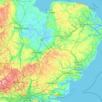
Nom : Carte topographique East of England, altitude, relief.
Lieu : East of England, England, United Kingdom (51.44828 -0.74579 52.99164 1.76891)
Altitude moyenne : 39 m
Altitude minimum : -5 m
Altitude maximum : 267 m
The East of England region has the lowest elevation range in the UK. Twenty percent of the region is below mean sea level, most of this in North Cambridgeshire, Norfolk and on the Essex Coast. Most of the remaining area is of low elevation, with extensive glacial deposits. The Fens, a large area of reclaimed marshland, are mostly in North Cambridgeshire. The Fens include the lowest point in the country in the village of Holme: 2.75 metres (9.0 ft) below mean sea level. This area formerly included the body of open water known as Whittlesey Mere. The highest point in the region is at Clipper Down at 817 ft (249 m) above mean sea level, in the far southwestern corner of the region in the Ivinghoe Hills.
Autres cartes topographiques
Cliquez sur une carte pour visualiser sa topographie, son altitude et son relief.
London
United Kingdom > England > London
London, Greater London, England, SW1A 2DX, United Kingdom
Altitude moyenne : 42 m
Bristol
United Kingdom > England > City of Bristol
Bristol, City of Bristol, West of England, England, United Kingdom
Altitude moyenne : 55 m
London
London, Greater London, England, United Kingdom
Altitude moyenne : 66 m
Lake District National Park
Lake District National Park, England, United Kingdom
Altitude moyenne : 206 m
South East England
South East England, England, United Kingdom
Altitude moyenne : 69 m
Newcastle upon Tyne
Newcastle upon Tyne, North of Tyne, England, United Kingdom
Altitude moyenne : 57 m
Kingston upon Thames
Kingston upon Thames, Greater London, England, KT1 1JS, United Kingdom
Altitude moyenne : 19 m
Liverpool
Liverpool, Liverpool City Region, England, United Kingdom
Altitude moyenne : 26 m
Greater London
Greater London, England, United Kingdom
Altitude moyenne : 66 m
Sheffield
Sheffield, South Yorkshire, England, United Kingdom
Altitude moyenne : 168 m
Leicestershire
Leicestershire, East Midlands, England, United Kingdom
Altitude moyenne : 97 m
Corby
United Kingdom > England > North Northamptonshire > Corby
Corby, North Northamptonshire, East Midlands, England, United Kingdom
Altitude moyenne : 98 m
Northamptonshire
Northamptonshire, England, United Kingdom
Altitude moyenne : 97 m
Greater Manchester
Greater Manchester, England, United Kingdom
Altitude moyenne : 141 m
Enfield
United Kingdom > England > London
Enfield, Greater London, England, EN2 6LD, United Kingdom
Altitude moyenne : 39 m
Coventry
Coventry, West Midlands Combined Authority, England, United Kingdom
Altitude moyenne : 99 m
Peterborough
United Kingdom > England > City of Peterborough
Peterborough, City of Peterborough, Cambridgeshire and Peterborough, England, PE1 1XH, United Kingdom
Altitude moyenne : 17 m
Yorkshire Dales National Park
Yorkshire Dales National Park, England, United Kingdom
Altitude moyenne : 298 m
Dorset
United Kingdom > England > Talbot Village
Dorset, Alder Road, Branksome, Talbot Village, Bournemouth, Christchurch and Poole, South West England, England, BH12 5BJ, United Kingdom
Altitude moyenne : 57 m
Stockport
Stockport, Greater Manchester, England, United Kingdom
Altitude moyenne : 95 m
Northumberland
Northumberland, North of Tyne, England, United Kingdom
Altitude moyenne : 141 m
Bradford
Bradford, West Yorkshire, England, United Kingdom
Altitude moyenne : 175 m
Hull
United Kingdom > England > Kingston upon Hull
Hull, Kingston upon Hull, England, HU1 3RJ, United Kingdom
Altitude moyenne : 21 m
Leicester
United Kingdom > England > Leicestershire
Leicester, Leicestershire, England, LE1 5YA, United Kingdom
Altitude moyenne : 109 m
East Suffolk
United Kingdom > England > Suffolk
East Suffolk, Suffolk, England, United Kingdom
Altitude moyenne : 22 m
The Cotswolds National Landscape
United Kingdom > England > Gloucestershire
The Cotswolds National Landscape, Gloucestershire, West of England, England, United Kingdom
Altitude moyenne : 109 m
Macclesfield
United Kingdom > England > Macclesfield
Macclesfield, Cheshire East, North West England, England, SK10 1EA, United Kingdom
Altitude moyenne : 189 m
Winchester
United Kingdom > England > Hampshire
Winchester, Hampshire, England, United Kingdom
Altitude moyenne : 73 m
Trerose
United Kingdom > England > Cornwall > Mawnan
Trerose, Mawnan, Cornwall, England, TR11 5HX, United Kingdom
Altitude moyenne : 24 m
North East England
North East England, England, United Kingdom
Altitude moyenne : 165 m
Gloucestershire
Gloucestershire, England, United Kingdom
Altitude moyenne : 99 m
West Midlands
United Kingdom > England > Warwickshire
West Midlands, Warwickshire, West Midlands Combined Authority, England, United Kingdom
Altitude moyenne : 113 m
Hampshire
Hampshire, South East, England, United Kingdom
Altitude moyenne : 73 m
Portishead
United Kingdom > England > Portishead
Portishead, North Somerset, South West England, England, BS20, United Kingdom
Altitude moyenne : 26 m
Bath
United Kingdom > England > Bath and North East Somerset
Bath, Bath and North East Somerset, West of England, England, United Kingdom
Altitude moyenne : 100 m
Birmingham
Birmingham, West Midlands Combined Authority, England, United Kingdom
Altitude moyenne : 138 m
Brighton
United Kingdom > England > Brighton and Hove
Brighton, Brighton and Hove, England, United Kingdom
Altitude moyenne : 64 m
Nottingham
United Kingdom > England > Nottinghamshire
Nottingham, England, United Kingdom
Altitude moyenne : 56 m
Durham
United Kingdom > England > County Durham
Durham, County Durham, North East, England, DH1 3NG, United Kingdom
Altitude moyenne : 119 m
Woodhouse Moor Park
United Kingdom > England > Leeds
Woodhouse Moor Park, Hyde Park, Leeds, West Yorkshire, England, LS2 3AP, United Kingdom
Altitude moyenne : 66 m