Géolocaliser

Carte topographique Staplecross

Cliquez sur la carte pour afficher l’altitude.

À propos de cette carte

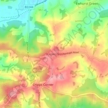
Nom : Carte topographique Staplecross, altitude, relief.

Lieu : Staplecross, Rother, East Sussex, England, TN32 5QG, United Kingdom (50.95417 0.51674 50.99417 0.55674)

Altitude moyenne : 58 m

Altitude minimum : 1 m

Altitude maximum : 113 m

Autres cartes topographiques

Cliquez sur une carte pour visualiser sa topographie, son altitude et son relief.

Camber

United Kingdom > England > East Sussex > Rother

Altitude moyenne : 1 m

Iden

United Kingdom > England > East Sussex > Rother > Iden

Altitude moyenne : 17 m

Guestling

United Kingdom > England > East Sussex > Rother > Guestling

Altitude moyenne : 40 m

Bewl Water

United Kingdom > England > East Sussex > Rother > Ticehurst

Altitude moyenne : 92 m

Rye

United Kingdom > England > East Sussex > Rother > Playden

The town and its striking surroundings have frequently served as subject for painters, many of whose works are now on display in its art gallery. One of the earliest topographical panoramas, dating from the 17th century when the town was still an island port, is in the style of Hendrick Danckerts and on…

Altitude moyenne : 7 m

Westfield

United Kingdom > England > East Sussex > Rother > Westfield

Altitude moyenne : 48 m

Burwash

United Kingdom > England > East Sussex > Rother > Burwash

Altitude moyenne : 83 m

Catsfield

United Kingdom > England > East Sussex > Rother

Altitude moyenne : 53 m

Battle

United Kingdom > England > East Sussex > Rother > Battle

Altitude moyenne : 66 m

Rye

United Kingdom > England > East Sussex > Rother

The town and its striking surroundings have frequently served as subject for painters, many of whose works are now on display in its art gallery. One of the earliest topographical panoramas, dating from the 17th century when the town was still an island port, is in the style of Hendrick Danckerts and on…

Altitude moyenne : 7 m

Udimore

United Kingdom > England > East Sussex > Rother

Altitude moyenne : 23 m

Playden

United Kingdom > England > East Sussex > Rother

Altitude moyenne : 17 m

Darwell Reservoir

United Kingdom > England > East Sussex > Rother

Altitude moyenne : 65 m

Ring Wood

United Kingdom > England > East Sussex > Rother > Crowhurst

Altitude moyenne : 24 m

Bodiam

United Kingdom > England > East Sussex > Rother

Altitude moyenne : 27 m

Brede

United Kingdom > England > East Sussex > Rother

Altitude moyenne : 40 m

Icklesham

United Kingdom > England > East Sussex > Rother

Altitude moyenne : 26 m

Catsfield

United Kingdom > England > East Sussex > Rother > Catsfield

Altitude moyenne : 53 m

Hurst Green

United Kingdom > England > East Sussex > Rother > Hurst Green

Altitude moyenne : 54 m

Northiam

United Kingdom > England > East Sussex > Rother

Altitude moyenne : 34 m

Ticehurst

United Kingdom > England > East Sussex > Rother

Altitude moyenne : 81 m

Mountfield

United Kingdom > England > East Sussex > Rother > Mountfield

Altitude moyenne : 63 m

Bewl Water

United Kingdom > England > East Sussex > Rother > Ticehurst

Altitude moyenne : 92 m

Guestling

United Kingdom > England > East Sussex > Rother > Guestling

Altitude moyenne : 39 m

Pett

United Kingdom > England > East Sussex > Rother

Altitude moyenne : 21 m

Rye

United Kingdom > England > East Sussex > Rother > Playden

The town and its striking surroundings have frequently served as subject for painters, many of whose works are now on display in its art gallery. One of the earliest topographical panoramas, dating from the 17th century when the town was still an island port, is in the style of Hendrick Danckerts and on…

Altitude moyenne : 7 m

Whatlington

United Kingdom > England > East Sussex > Rother

Altitude moyenne : 53 m

Brightling

United Kingdom > England > East Sussex > Rother

Altitude moyenne : 94 m

Sedlescombe

United Kingdom > England > East Sussex > Rother

Altitude moyenne : 47 m

Peasmarsh

United Kingdom > England > East Sussex > Rother > Peasmarsh

Altitude moyenne : 24 m

Udimore

United Kingdom > England > East Sussex > Rother

Altitude moyenne : 23 m

Battle

United Kingdom > England > East Sussex > Rother > Battle

Altitude moyenne : 66 m

Etchingham

United Kingdom > England > East Sussex > Rother

Altitude moyenne : 46 m

Fairlight

United Kingdom > England > East Sussex > Rother

Altitude moyenne : 47 m

Dallington

United Kingdom > England > East Sussex > Rother

Altitude moyenne : 109 m

Camber Sands

United Kingdom > England > East Sussex > Rother > Camber

Altitude moyenne : 2 m

Battle

United Kingdom > England > East Sussex > Rother > Battle

Altitude moyenne : 66 m

Équipez-vous pour votre prochaine aventure :

🌧️Poncho imperméable - Protection rapide et efficace contre les averses soudaines en montagne
🗺️Atlas géographiques - Références cartographiques
🎒Sac d'hydratation VTT - Design ergonomique pour ne pas gêner les mouvements en descente
🍼Gourde inox isotherme - Conserve le café chaud ou l'eau fraîche pendant des heures
🧼Savon biodégradable - Lavez-vous ou nettoyez votre matériel sans polluer les rivières

En tant que Partenaire Amazon, ce site perçoit une commission sur les achats éligibles sans surcoût pour vous.