
Carte topographique Catsfield
Cliquez sur la carte pour afficher l’altitude.
À propos de cette carte
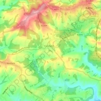
Nom : Carte topographique Catsfield, altitude, relief.
Lieu : Catsfield, Rother, East Sussex, England, United Kingdom (50.87282 0.40648 50.91723 0.49040)
Altitude moyenne : 53 m
Altitude minimum : 1 m
Altitude maximum : 118 m
Autres cartes topographiques
Cliquez sur une carte pour visualiser sa topographie, son altitude et son relief.
Highwoods SSSI
United Kingdom > England > East Sussex > Rother > Bexhill-on-Sea
Altitude moyenne : 28 m
Northbridge Street
United Kingdom > England > East Sussex > Rother > Robertsbridge
Altitude moyenne : 40 m
John's Cross
United Kingdom > England > East Sussex > Rother > Mountfield > John's Cross
Altitude moyenne : 53 m
Union Street
United Kingdom > England > East Sussex > Rother > Flimwell > Union Street
Altitude moyenne : 97 m
Battle of Hastings
United Kingdom > England > East Sussex > Rother > Catsfield
Battle Abbey was founded by William at the site of the battle. According to 12th-century sources, William made a vow to found the abbey, and the high altar of the church was placed at the site where Harold had died. More likely, the foundation was imposed on William by papal legates in 1070. The topography of…
Altitude moyenne : 60 m