
Carte topographique Laurys Station
Carte interactive
Cliquez sur la carte pour afficher l’altitude.
À propos de cette carte
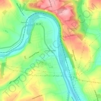
Nom : Carte topographique Laurys Station, altitude, relief.
Altitude moyenne : 152 m
Altitude minimum : 84 m
Altitude maximum : 242 m
Autres cartes topographiques
Cliquez sur une carte pour visualiser sa topographie, son altitude et son relief.
Neffs
United States > Pennsylvania > Lehigh County > North Whitehall Township
Neffs, North Whitehall Township, Lehigh County, Pennsylvania, 18065, United States
Altitude moyenne : 208 m
Schnecksville
United States > Pennsylvania > Lehigh County > North Whitehall Township
Schnecksville, North Whitehall Township, Lehigh County, Pennsylvania, 18078, United States
Altitude moyenne : 197 m