
Carte topographique Schnecksville
Carte interactive
Cliquez sur la carte pour afficher l’altitude.
À propos de cette carte
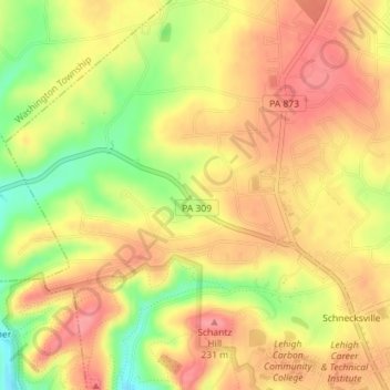
Nom : Carte topographique Schnecksville, altitude, relief.
Altitude moyenne : 197 m
Altitude minimum : 144 m
Altitude maximum : 229 m
According to the U.S. Census Bureau, Schnecksville has a total area of 2.7 square miles (7.0 km2), of which 0.01 square miles (0.02 km2), or 0.28%, are water. Schnecksville sits on a ridge at an elevation of about 660 feet (200 m) above sea level. To the west, water flows to Jordan Creek, while to the east water flows to Coplay Creek. Both creeks are southeast-flowing tributaries of the Lehigh River and part of the Delaware River watershed.
Autres cartes topographiques
Cliquez sur une carte pour visualiser sa topographie, son altitude et son relief.
Neffs
United States > Pennsylvania > Lehigh County > North Whitehall Township
Neffs, North Whitehall Township, Lehigh County, Pennsylvania, 18065, United States
Altitude moyenne : 208 m
Laurys Station
United States > Pennsylvania > Lehigh County > North Whitehall Township
Laurys Station, North Whitehall Township, Lehigh County, Pennsylvania, 18059, United States
Altitude moyenne : 152 m