
Carte topographique Springer Mountain
Carte interactive
Cliquez sur la carte pour afficher l’altitude.
À propos de cette carte
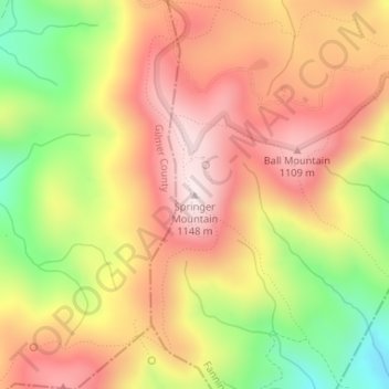
Nom : Carte topographique Springer Mountain, altitude, relief.
Lieu : Springer Mountain, Fannin County, Georgia, United States (34.62660 -84.19358 34.62670 -84.19348)
Altitude moyenne : 941 m
Altitude minimum : 670 m
Altitude maximum : 1’141 m
Springer Mountain is a mountain located in the Chattahoochee National Forest on the border of Fannin and Gilmer counties. Located in the Blue Ridge Mountains in northern Georgia, the mountain has an elevation of about 3,782 feet (1,153 m). Springer Mountain serves as the southern terminus for the Appalachian and Benton MacKaye trails.
Autres cartes topographiques
Cliquez sur une carte pour visualiser sa topographie, son altitude et son relief.
Blue Ridge
United States > Georgia > Fannin County
Blue Ridge, Fannin County, Georgia, United States
Altitude moyenne : 535 m
Wilscot
United States > Georgia > Fannin County
Wilscot, Fannin County, Georgia, United States
Altitude moyenne : 614 m
Aska
United States > Georgia > Fannin County
Aska, Fannin County, Georgia, United States
Altitude moyenne : 629 m
Greens Mill
United States > Georgia > Fannin County
Greens Mill, Fannin County, Georgia, 30513, United States
Altitude moyenne : 566 m
Dial
United States > Georgia > Fannin County
Dial, Fannin County, Georgia, United States
Altitude moyenne : 612 m
Colwell
United States > Georgia > Fannin County
Colwell, Fannin County, Georgia, United States
Altitude moyenne : 630 m
Higdon
United States > Georgia > Fannin County
Higdon, Fannin County, Georgia, 30541, United States
Altitude moyenne : 595 m
Lake Blue Ridge
United States > Georgia > Fannin County > Morganton
Lake Blue Ridge, Morganton, Fannin County, Georgia, United States
Altitude moyenne : 572 m
Cordell Mountain
United States > Georgia > Fannin County
Cordell Mountain, Fannin County, Georgia, 30559, United States
Altitude moyenne : 601 m
Ocoee River
United States > Georgia > Fannin County
Ocoee River, Fannin County, East Tennessee, Georgia, 30572, United States
Altitude moyenne : 579 m
McCaysville
United States > Georgia > Fannin County
McCaysville, Fannin County, Georgia, United States
Altitude moyenne : 484 m
Morganton
United States > Georgia > Fannin County
Morganton, Fannin County, Georgia, United States
Altitude moyenne : 538 m
Mineral Bluff
United States > Georgia > Fannin County
Mineral Bluff, Fannin County, Georgia, 30559, United States
Altitude moyenne : 516 m
Kyle
United States > Georgia > Fannin County
Kyle, Fannin County, Georgia, 30555, United States
Altitude moyenne : 508 m
Epworth
United States > Georgia > Fannin County > Epworth
Epworth, Fannin County, Georgia, 30555, United States
Altitude moyenne : 524 m
Loving
United States > Georgia > Fannin County > Loving
Loving, Fannin County, Georgia, 30560, United States
Altitude moyenne : 577 m