
Carte topographique McCaysville
Carte interactive
Cliquez sur la carte pour afficher l’altitude.
À propos de cette carte
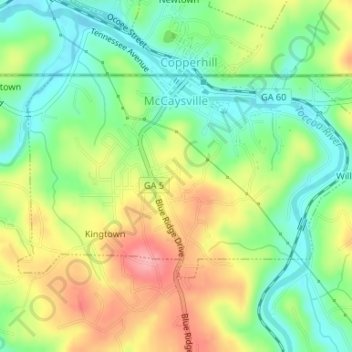
Nom : Carte topographique McCaysville, altitude, relief.
Lieu : McCaysville, Fannin County, Georgia, United States (34.97250 -84.38621 34.98815 -84.35309)
Altitude moyenne : 484 m
Altitude minimum : 437 m
Altitude maximum : 548 m
McCaysville's weather is temperate due to its elevation and location in the southern Appalachians. Summers are warm with average highs in the middle 80s and lows in the lower 60s. Winters are cool with average highs in the 40s and average lows in the 20s. Rainfall is abundant with the yearly average approaching 67 inches and occurring on 127 days. Snowfall usually occurs on several occasions during the winter months and can range from a light dusting to the occasional significant storm. The most significant snow storm to hit the area occurred March 12–14, 1993, when the area received approximately 40 inches in what eastern seaboard residents often refer to as "the storm of the century". The average first frost occurs in mid-October with the average last frost occurring in late April.
Autres cartes topographiques
Cliquez sur une carte pour visualiser sa topographie, son altitude et son relief.
Blue Ridge
United States > Georgia > Fannin County
Blue Ridge, Fannin County, Georgia, United States
Altitude moyenne : 535 m
Wilscot
United States > Georgia > Fannin County
Wilscot, Fannin County, Georgia, United States
Altitude moyenne : 614 m
Aska
United States > Georgia > Fannin County
Aska, Fannin County, Georgia, United States
Altitude moyenne : 629 m
Greens Mill
United States > Georgia > Fannin County
Greens Mill, Fannin County, Georgia, 30513, United States
Altitude moyenne : 566 m
Dial
United States > Georgia > Fannin County
Dial, Fannin County, Georgia, United States
Altitude moyenne : 612 m
Colwell
United States > Georgia > Fannin County
Colwell, Fannin County, Georgia, United States
Altitude moyenne : 630 m
Higdon
United States > Georgia > Fannin County
Higdon, Fannin County, Georgia, 30541, United States
Altitude moyenne : 595 m
Lake Blue Ridge
United States > Georgia > Fannin County > Morganton
Lake Blue Ridge, Morganton, Fannin County, Georgia, United States
Altitude moyenne : 572 m
Cordell Mountain
United States > Georgia > Fannin County
Cordell Mountain, Fannin County, Georgia, 30559, United States
Altitude moyenne : 601 m
Springer Mountain
United States > Georgia > Fannin County
Springer Mountain, Fannin County, Georgia, United States
Altitude moyenne : 941 m
Ocoee River
United States > Georgia > Fannin County
Ocoee River, Fannin County, East Tennessee, Georgia, 30572, United States
Altitude moyenne : 579 m
Morganton
United States > Georgia > Fannin County
Morganton, Fannin County, Georgia, United States
Altitude moyenne : 538 m
Mineral Bluff
United States > Georgia > Fannin County
Mineral Bluff, Fannin County, Georgia, 30559, United States
Altitude moyenne : 516 m
Kyle
United States > Georgia > Fannin County
Kyle, Fannin County, Georgia, 30555, United States
Altitude moyenne : 508 m
Epworth
United States > Georgia > Fannin County > Epworth
Epworth, Fannin County, Georgia, 30555, United States
Altitude moyenne : 524 m
Loving
United States > Georgia > Fannin County > Loving
Loving, Fannin County, Georgia, 30560, United States
Altitude moyenne : 577 m