
Carte topographique Lake Louise
Carte interactive
Cliquez sur la carte pour afficher l’altitude.
À propos de cette carte
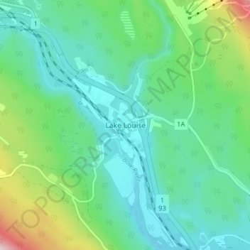
Nom : Carte topographique Lake Louise, altitude, relief.
Lieu : Lake Louise, Division No. 15, Alberta, Canada (51.40497 -116.19754 51.44497 -116.15754)
Altitude moyenne : 1’617 m
Altitude minimum : 1’518 m
Altitude maximum : 1’934 m
Lake Louise is a hamlet within Banff National Park in Alberta, Canada. Named after Princess Louise, Duchess of Argyll, it lies in Alberta's Rockies on the Bow River, 3 km (1.9 mi) northeast of the lake that shares its name. Initially settled in 1884 as an outpost for the Canadian Pacific Railway, Lake Louise sits at an elevation of 1,600 m (5,200 ft), making it Canada's highest community. The nearby lake, framed by mountains, is one of the most famous mountain vistas in the world; the famous Chateau Lake Louise also overlooks the lake.[4]
Autres cartes topographiques
Cliquez sur une carte pour visualiser sa topographie, son altitude et son relief.
Banff National Park
Canada > Alberta > Division No. 15
Banff National Park, Division No. 15, Alberta, Canada
Altitude moyenne : 1’848 m
Moraine Lake
Canada > Alberta > Division No. 15
Moraine Lake, Division No. 15, Alberta, Canada
Altitude moyenne : 2’101 m
Jasper National Park
Canada > Alberta > Division No. 15
Jasper National Park, Division No. 15, Alberta, Canada
Altitude moyenne : 1’782 m
Toronto Peak
Canada > Alberta > Division No. 15
Toronto Peak, Division No. 15, Alberta, Canada
Altitude moyenne : 2’423 m