
Carte topographique Parc national de Banff
Carte interactive
Cliquez sur la carte pour afficher l’altitude.
Parc national de Banff
Le paysage de Banff est également marqué par l'érosion glaciaire, avec des vallées profondes en forme de U et de nombreuses vallées suspendues qui se terminent souvent en chute d'eau. Des montagnes à l'aspect pyramidal, telles que le mont Assiniboine, ont été façonnées par l'érosion glaciaire. De nombreuses petites gorges existent également, comme le canyon Mistaya et le canyon Johnston. L'altitude dans le parc varie de 1 350 m dans la vallée de la Bow à 3 618 m au sommet du mont Assiniboine.
À propos de cette carte
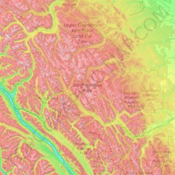
Nom : Carte topographique Parc national de Banff, altitude, relief.
Lieu : Parc national de Banff, Alberta, Canada (50.70506 -117.31712 52.27145 -115.16491)
Altitude moyenne : 1’848 m
Altitude minimum : 773 m
Altitude maximum : 3’472 m
Autres cartes topographiques
Cliquez sur une carte pour visualiser sa topographie, son altitude et son relief.
Pyramid Mountain
Canada > Alberta > Division No. 15 > Municipality of Jasper
Altitude moyenne : 2’152 m
Summer Village of Yellowstone
Canada > Alberta > Yellowstone (summer village) > Summer Village of Yellowstone
Altitude moyenne : 733 m