
Carte topographique Gokyo Ri
Carte interactive
Cliquez sur la carte pour afficher l’altitude.
À propos de cette carte
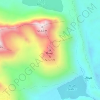
Nom : Carte topographique Gokyo Ri, altitude, relief.
Altitude moyenne : 4’968 m
Altitude minimum : 4’722 m
Altitude maximum : 5’461 m
Autres cartes topographiques
Cliquez sur une carte pour visualiser sa topographie, son altitude et son relief.
Tengboche
Nepal > Solukhumbu > Khumjung > Tengboche
Tengboche, Khumjung, Khumbupasanglahmu, Solukhumbu, Province #1, Nepal
Altitude moyenne : 3’936 m
Khumbu Glacier
Nepal > Solukhumbu > Khumjung
Khumbu Glacier, Khumjung, Khumbupasanglahmu, Solukhumbu, Province #1, Nepal
Altitude moyenne : 6’296 m
Himalayas
Nepal > Solukhumbu > Khumjung
Himalayas, Khumjung, Khumbupasanglahmu, Solukhumbu, Province #1, Nepal
Altitude moyenne : 7’555 m