
Carte topographique Khumbu Glacier
Carte interactive
Cliquez sur la carte pour afficher l’altitude.
À propos de cette carte
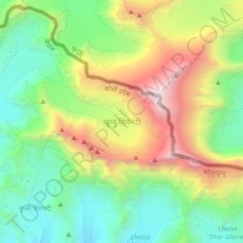
Nom : Carte topographique Khumbu Glacier, altitude, relief.
Altitude moyenne : 6’296 m
Altitude minimum : 5’027 m
Altitude maximum : 8’849 m
The Khumbu Glacier (Nepali: खुम्बु हिमनदी) is located in the Khumbu region of northeastern Nepal between Mount Everest and the Lhotse-Nuptse ridge. With elevations of 4,900 m (16,100 ft) at its terminus to 7,600 m (24,900 ft) at its source, it is the world's highest glacier. The Khumbu Glacier is followed for the final part of the trail to one of the Everest Base Camps. The start of the glacier is in the Western Cwm near Everest. The glacier has a large icefall, the Khumbu Icefall, at the west end of the lower Western Cwm. This icefall is the first major obstacle—and among the more dangerous—on the standard south col route to the Everest summit. It is also the largest glacier of Nepal.
Autres cartes topographiques
Cliquez sur une carte pour visualiser sa topographie, son altitude et son relief.
Tengboche
Nepal > Solukhumbu > Khumjung > Tengboche
Tengboche, Khumjung, Khumbupasanglahmu, Solukhumbu, Province #1, Nepal
Altitude moyenne : 3’936 m
Gokyo Ri
Nepal > Solukhumbu > Khumjung
Gokyo Ri, Khumjung, Khumbupasanglahmu, Solukhumbu, Province #1, Nepal
Altitude moyenne : 4’968 m
Himalayas
Nepal > Solukhumbu > Khumjung
Himalayas, Khumjung, Khumbupasanglahmu, Solukhumbu, Province #1, Nepal
Altitude moyenne : 7’555 m