
Carte topographique Corner Hall
Cliquez sur la carte pour afficher l’altitude.
À propos de cette carte
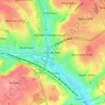
Nom : Carte topographique Corner Hall, altitude, relief.
Altitude moyenne : 120 m
Altitude minimum : 75 m
Altitude maximum : 160 m
Autres cartes topographiques
Cliquez sur une carte pour visualiser sa topographie, son altitude et son relief.
Berkhamsted
United Kingdom > England > Hertfordshire > Dacorum > Northchurch
The layout of Berkhamsted's centre is typical of a medieval market settlement: the linear High Street (aligned on the Akeman Street) forms the spine of the town (roughly aligned east–west), from which extend medieval burgage plots (to the north and south). The surviving burgage plot layout is the result of a…
Altitude moyenne : 142 m
Saint Margarets Copse
United Kingdom > England > Hertfordshire > Dacorum > Great Gaddesden
Altitude moyenne : 144 m
Tringford Reservoir
United Kingdom > England > Hertfordshire > Dacorum > Tring > Wilstone
Altitude moyenne : 119 m
Great Gaddesden
United Kingdom > England > Hertfordshire > Dacorum > Gaddesden Row
Altitude moyenne : 146 m
Westbrook Mere
United Kingdom > England > Hertfordshire > Dacorum > Bourne End
Altitude moyenne : 125 m
Phasels Wood
United Kingdom > England > Hertfordshire > Dacorum > Kings Langley > Felden
Altitude moyenne : 128 m
Frithsden Beeches
United Kingdom > England > Hertfordshire > Dacorum > Potten End
Altitude moyenne : 160 m
Little Gaddesden
United Kingdom > England > Hertfordshire > Dacorum > Little Gaddesden
Altitude moyenne : 175 m
Berkhamsted
United Kingdom > England > Hertfordshire > Dacorum
The layout of Berkhamsted's centre is typical of a medieval market settlement: the linear High Street (aligned on the Akeman Street) forms the spine of the town (roughly aligned east–west), from which extend medieval burgage plots (to the north and south). The surviving burgage plot layout is the result of a…
Altitude moyenne : 145 m