
Carte topographique Berkhamsted
Cliquez sur la carte pour afficher l’altitude.
Berkhamsted
The layout of Berkhamsted's centre is typical of a medieval market settlement: the linear High Street (aligned on the Akeman Street) forms the spine of the town (roughly aligned east–west), from which extend medieval burgage plots (to the north and south). The surviving burgage plot layout is the result of a comprehensive plan carried out at the beginning of the 13th century, most probably instigated by Geoffrey fitz Peter. The town centre slowly developed over the years and contains a wide variety of properties that date from the 13th century onwards. The modern town began to develop after the construction of the Grand Junction Canal in 1798. The canal intersects the river at numerous points, taking most of its water supply and helping to drain the valley. The locality became further urbanised when the London to Birmingham railway was built in 1836–37. The townscape was shaped by the Bulbourne valley, which rises 300 feet (91 metres) on either side at its narrowest point; the residential area is elongated and follows the valley's topography. The southwest side of the valley is more developed, with side streets running up the steep hillside; on the northeast side, the ground gently slopes down to the castle, railway, canal and small river, was less available for development. Today, Berkhamsted is an affluent, "pleasant town tucked in a wooded fold in the Chiltern Hills"; with a large section of the settlement protected as a conservation area.
À propos de cette carte
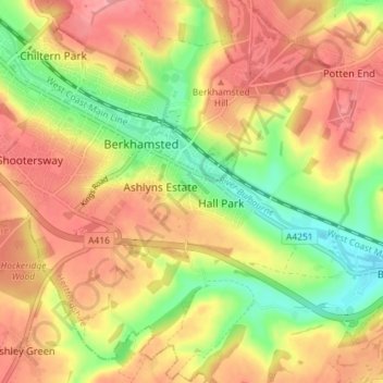
Nom : Carte topographique Berkhamsted, altitude, relief.
Lieu : Berkhamsted, Dacorum, Hertfordshire, England, United Kingdom (51.73573 -0.59360 51.77455 -0.52201)
Altitude moyenne : 145 m
Altitude minimum : 91 m
Altitude maximum : 182 m
Autres cartes topographiques
Cliquez sur une carte pour visualiser sa topographie, son altitude et son relief.
Saint Margarets Copse
United Kingdom > England > Hertfordshire > Dacorum > Great Gaddesden
Altitude moyenne : 144 m
Hammerfield
United Kingdom > England > Hertfordshire > Dacorum > Hemel Hempstead
Altitude moyenne : 122 m
Tringford Reservoir
United Kingdom > England > Hertfordshire > Dacorum > Tring > Wilstone
Altitude moyenne : 119 m
Dixon's Gap Bridge
United Kingdom > England > Hertfordshire > Dacorum > Wilstone > Gubblecote
Altitude moyenne : 101 m
Westbrook Mere
United Kingdom > England > Hertfordshire > Dacorum > Bourne End
Altitude moyenne : 125 m
Trowley Bottom
United Kingdom > England > Hertfordshire > Dacorum > Flamstead
Altitude moyenne : 139 m
Nettleden
United Kingdom > England > Hertfordshire > Dacorum > Great Gaddesden
Altitude moyenne : 149 m
Bovingdon Green
United Kingdom > England > Hertfordshire > Dacorum > Bovingdon
Altitude moyenne : 151 m
Long Marston
United Kingdom > England > Hertfordshire > Dacorum > Long Marston
Altitude moyenne : 92 m
Frithsden Beeches
United Kingdom > England > Hertfordshire > Dacorum > Potten End
Altitude moyenne : 160 m