
Carte topographique Stratham
Carte interactive
Cliquez sur la carte pour afficher l’altitude.
À propos de cette carte
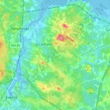
Nom : Carte topographique Stratham, altitude, relief.
Altitude moyenne : 22 m
Altitude minimum : -10 m
Altitude maximum : 85 m
According to the United States Census Bureau, the town has a total area of 15.5 square miles (40.2 km2), of which 15.1 square miles (39.2 km2) are land and 0.3 square miles (0.9 km2) are water, comprising 2.29% of the town. Most of Stratham is drained by the Squamscott River, a north-flowing tributary of Great Bay. The east side of the town drains to the Winnicut River, which also flows to Great Bay. The entire town is part of the Piscataqua River watershed. The highest elevation in town is 290 feet (88 m) above sea level, found on the summits of Stratham Hill and neighboring Jewell Hill, both glacial drumlins.
Autres cartes topographiques
Cliquez sur une carte pour visualiser sa topographie, son altitude et son relief.
East Kingston
United States > New Hampshire > Rockingham County
East Kingston, Rockingham County, New Hampshire, United States
Altitude moyenne : 38 m
Providence Hill
United States > New Hampshire > Rockingham County > Atkinson
Providence Hill, Atkinson, Rockingham County, New Hampshire, 03811, United States
Altitude moyenne : 72 m
Hampstead
United States > New Hampshire > Rockingham County
Hampstead, Rockingham County, New Hampshire, United States
Altitude moyenne : 81 m
Auburn
United States > New Hampshire > Rockingham County
Auburn, Rockingham County, New Hampshire, 03032, United States
Altitude moyenne : 107 m
Epping
United States > New Hampshire > Rockingham County
Epping, Rockingham County, New Hampshire, 03042, United States
Altitude moyenne : 55 m
Fremont
United States > New Hampshire > Rockingham County
Fremont, Rockingham County, New Hampshire, 03044, United States
Altitude moyenne : 58 m
North Danville
United States > New Hampshire > Rockingham County > Danville
North Danville, Danville, Rockingham County, New Hampshire, 03819, United States
Altitude moyenne : 62 m
Peppermint Corner
United States > New Hampshire > Rockingham County > Derry
Peppermint Corner, Derry, Rockingham County, New Hampshire, 03038, United States
Altitude moyenne : 94 m
Salem Depot
United States > New Hampshire > Rockingham County > Salem > Salem Depot
Salem Depot, Salem, Rockingham County, New Hampshire, 03079, United States
Altitude moyenne : 50 m
Rye
United States > New Hampshire > Rockingham County
Rye, Rockingham County, New Hampshire, United States
Altitude moyenne : 9 m
Rye Beach Village District
United States > New Hampshire > Rockingham County > Rye Beach Village District
Rye Beach Village District, Rye, Rockingham County, New Hampshire, 03871, United States
Altitude moyenne : 7 m
Newmarket
United States > New Hampshire > Rockingham County > Newmarket
Newmarket, Rockingham County, New Hampshire, 03857, United States
Altitude moyenne : 21 m
Kensington
United States > New Hampshire > Rockingham County
Kensington, Rockingham County, New Hampshire, United States
Altitude moyenne : 32 m
Windham
United States > New Hampshire > Rockingham County
Windham, Rockingham County, New Hampshire, 03087, United States
Altitude moyenne : 81 m
Collettes Grove
United States > New Hampshire > Rockingham County > Derry
Collettes Grove, Derry, Rockingham County, New Hampshire, 03841, United States
Altitude moyenne : 79 m
Kingston
United States > New Hampshire > Rockingham County
Kingston, Rockingham County, New Hampshire, United States
Altitude moyenne : 45 m
North Hampton
United States > New Hampshire > Rockingham County > North Hampton
North Hampton, Rockingham County, New Hampshire, 03862, United States
Altitude moyenne : 18 m
Salem
United States > New Hampshire > Rockingham County
Salem, Rockingham County, New Hampshire, 03079, United States
Altitude moyenne : 60 m
Londonderry
United States > New Hampshire > Rockingham County > Londonderry
Londonderry, Rockingham County, New Hampshire, 03053, United States
Altitude moyenne : 91 m
Newington
United States > New Hampshire > Rockingham County
Newington, Rockingham County, New Hampshire, United States
Altitude moyenne : 10 m
South Hampton
United States > New Hampshire > Rockingham County
South Hampton, Rockingham County, New Hampshire, United States
Altitude moyenne : 38 m
Exeter
United States > New Hampshire > Rockingham County
Exeter, Rockingham County, New Hampshire, United States
Altitude moyenne : 24 m
Hampton
United States > New Hampshire > Rockingham County
Hampton, Rockingham County, New Hampshire, 03842, United States
Altitude moyenne : 11 m
The Sands
United States > New Hampshire > Rockingham County > Seabrook
The Sands, Seabrook, Rockingham County, New Hampshire, 03874, United States
Altitude moyenne : 1 m