
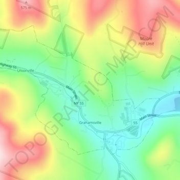
Carte topographique Grahamsville
Carte interactive
Cliquez sur la carte pour afficher l’altitude.
À propos de cette carte
Nom : Carte topographique Grahamsville, altitude, relief.
Altitude moyenne : 397 m
Altitude minimum : 249 m
Altitude maximum : 596 m
Grahamsville is located at latitude 41.848 and longitude -74.548. The elevation is 968 feet. Grahamsville is in the Eastern Time Zone.
Autres cartes topographiques
Cliquez sur une carte pour visualiser sa topographie, son altitude et son relief.
Claryville
United States > New York > Sullivan County > Town of Neversink
Claryville, Town of Neversink, Sullivan County, New York, 12725, United States
Altitude moyenne : 628 m
Unionville
United States > New York > Sullivan County > Town of Neversink
Unionville, Grahamsville, Town of Neversink, Sullivan County, New York, 12740, United States
Altitude moyenne : 450 m
Willowemoc
United States > New York > Sullivan County > Town of Neversink
Willowemoc, Town of Neversink, Sullivan County, New York, United States
Altitude moyenne : 630 m