
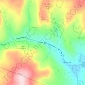
Carte topographique Unionville
Carte interactive
Cliquez sur la carte pour afficher l’altitude.
À propos de cette carte
Nom : Carte topographique Unionville, altitude, relief.
Altitude moyenne : 450 m
Altitude minimum : 270 m
Altitude maximum : 673 m
Autres cartes topographiques
Cliquez sur une carte pour visualiser sa topographie, son altitude et son relief.
Claryville
United States > New York > Sullivan County > Town of Neversink
Claryville, Town of Neversink, Sullivan County, New York, 12725, United States
Altitude moyenne : 628 m
Grahamsville
United States > New York > Sullivan County > Town of Neversink
Grahamsville, Town of Neversink, Sullivan County, New York, United States
Altitude moyenne : 397 m
Willowemoc
United States > New York > Sullivan County > Town of Neversink
Willowemoc, Town of Neversink, Sullivan County, New York, United States
Altitude moyenne : 630 m