
Faire un don
Équipez-vous pour votre prochaine aventure :
En tant que Partenaire Amazon, ce site perçoit une commission sur les achats éligibles sans surcoût pour vous.
Carte topographique Wolf Island
Cliquez sur la carte pour afficher l’altitude.
Faire un don
Équipez-vous pour votre prochaine aventure :
En tant que Partenaire Amazon, ce site perçoit une commission sur les achats éligibles sans surcoût pour vous.
À propos de cette carte
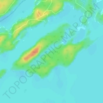
Nom : Carte topographique Wolf Island, altitude, relief.
Altitude moyenne : 327 m
Altitude minimum : 318 m
Altitude maximum : 359 m
Faire un don
Équipez-vous pour votre prochaine aventure :
En tant que Partenaire Amazon, ce site perçoit une commission sur les achats éligibles sans surcoût pour vous.
Autres cartes topographiques
Cliquez sur une carte pour visualiser sa topographie, son altitude et son relief.
MacDowell Lake
Canada > Ontario > Kenora District > Unorganized Kenora District
Altitude moyenne : 386 m
Lake Charles
Canada > Ontario > Kenora District > Unorganized Kenora District
Altitude moyenne : 346 m
Faire un don
Équipez-vous pour votre prochaine aventure :
En tant que Partenaire Amazon, ce site perçoit une commission sur les achats éligibles sans surcoût pour vous.
Fiddler Lake
Canada > Ontario > Kenora District > Unorganized Kenora District
Altitude moyenne : 293 m
Big Canon Lake
Canada > Ontario > Kenora District > Unorganized Kenora District
Altitude moyenne : 363 m
Faire un don
Équipez-vous pour votre prochaine aventure :
En tant que Partenaire Amazon, ce site perçoit une commission sur les achats éligibles sans surcoût pour vous.
Hudson Bay Lowlands
Canada > Ontario > Kenora District > Unorganized Kenora District
Altitude moyenne : 17 m
Minnitaki Lake
Canada > Ontario > Kenora District > Unorganized Kenora District
Altitude moyenne : 386 m
Faire un don
Équipez-vous pour votre prochaine aventure :
En tant que Partenaire Amazon, ce site perçoit une commission sur les achats éligibles sans surcoût pour vous.
Dogtooth Lake
Canada > Ontario > Kenora District > Unorganized Kenora District
Altitude moyenne : 361 m
Maynard Lake
Canada > Ontario > Kenora District > Unorganized Kenora District
Altitude moyenne : 337 m
Clearwater Bay
Canada > Ontario > Kenora District > Unorganized Kenora District
Altitude moyenne : 334 m
Faire un don
Équipez-vous pour votre prochaine aventure :
En tant que Partenaire Amazon, ce site perçoit une commission sur les achats éligibles sans surcoût pour vous.
Confederation Lake
Canada > Ontario > Kenora District > Unorganized Kenora District
Altitude moyenne : 414 m
Fredart Lake
Canada > Ontario > Kenora District > Unorganized Kenora District
Altitude moyenne : 409 m
Faire un don
Équipez-vous pour votre prochaine aventure :
En tant que Partenaire Amazon, ce site perçoit une commission sur les achats éligibles sans surcoût pour vous.
Two Island Lake
Canada > Ontario > Kenora District > Unorganized Kenora District
Altitude moyenne : 361 m
Affleck Lake
Canada > Ontario > Kenora District > Unorganized Kenora District
Altitude moyenne : 421 m
Spadina Lake
Canada > Ontario > Kenora District > Unorganized Kenora District
Altitude moyenne : 376 m
lac Seul
Canada > Ontario > Kenora District > Unorganized Kenora District
Lac Seul is a large, crescent shaped reservoir in Kenora District, northwestern Ontario, Canada. It is approximately 241 km (150 mi) long. It has a maximum (regulated) depth of 47.2 m, with a surface elevation of 357 m above sea level. Its level is raised in the summer and then drawn down in the winter months…
Altitude moyenne : 374 m
Faire un don
Équipez-vous pour votre prochaine aventure :
En tant que Partenaire Amazon, ce site perçoit une commission sur les achats éligibles sans surcoût pour vous.
McIntosh Lake
Canada > Ontario > Kenora District > Unorganized Kenora District
Altitude moyenne : 395 m
Gordon Island
Canada > Ontario > Kenora District > Unorganized Kenora District
Altitude moyenne : 349 m
Faire un don
Équipez-vous pour votre prochaine aventure :
En tant que Partenaire Amazon, ce site perçoit une commission sur les achats éligibles sans surcoût pour vous.
Blackstone Lake
Canada > Ontario > Kenora District > Unorganized Kenora District
Altitude moyenne : 382 m
Faire un don
Équipez-vous pour votre prochaine aventure :
En tant que Partenaire Amazon, ce site perçoit une commission sur les achats éligibles sans surcoût pour vous.
Winnipeg River
Canada > Ontario > Kenora District > Unorganized Kenora District
Altitude moyenne : 317 m
Faire un don
Équipez-vous pour votre prochaine aventure :
En tant que Partenaire Amazon, ce site perçoit une commission sur les achats éligibles sans surcoût pour vous.
Faire un don
Équipez-vous pour votre prochaine aventure :
En tant que Partenaire Amazon, ce site perçoit une commission sur les achats éligibles sans surcoût pour vous.
Mackey Island
Canada > Ontario > Kenora District > Unorganized Kenora District
Altitude moyenne : 336 m
Faire un don
Équipez-vous pour votre prochaine aventure :
En tant que Partenaire Amazon, ce site perçoit une commission sur les achats éligibles sans surcoût pour vous.
Whitefish Lake
Canada > Ontario > Kenora District > Unorganized Kenora District
Altitude moyenne : 380 m
Wabaskang Lake
Canada > Ontario > Kenora District > Unorganized Kenora District
Altitude moyenne : 375 m
Faire un don
Équipez-vous pour votre prochaine aventure :
En tant que Partenaire Amazon, ce site perçoit une commission sur les achats éligibles sans surcoût pour vous.
Kukukus Lake
Canada > Ontario > Kenora District > Unorganized Kenora District
Altitude moyenne : 405 m
Minnitaki Lake
Canada > Ontario > Kenora District > Unorganized Kenora District
Altitude moyenne : 386 m
Cluster Lakes
Canada > Ontario > Kenora District > Unorganized Kenora District
Altitude moyenne : 443 m
Faire un don
Équipez-vous pour votre prochaine aventure :
En tant que Partenaire Amazon, ce site perçoit une commission sur les achats éligibles sans surcoût pour vous.
Antenna Lake
Canada > Ontario > Kenora District > Unorganized Kenora District
Altitude moyenne : 393 m
Cameron Island
Canada > Ontario > Kenora District > Unorganized Kenora District
Altitude moyenne : 338 m
Faire un don
Équipez-vous pour votre prochaine aventure :
En tant que Partenaire Amazon, ce site perçoit une commission sur les achats éligibles sans surcoût pour vous.