
Carte topographique Wales
Carte interactive
Cliquez sur la carte pour afficher l’altitude.
À propos de cette carte
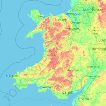
Nom : Carte topographique Wales, altitude, relief.
Lieu : Wales, United Kingdom (51.22903 -5.80773 53.63500 -2.64986)
Altitude moyenne : 99 m
Altitude minimum : 0 m
Altitude maximum : 1’001 m
Much of Wales' diverse landscape is mountainous, particularly in the north and central regions. The mountains were shaped during the last ice age, the Devensian glaciation. The highest mountains in Wales are in Snowdonia (Eryri), of which five are over 1,000 m (3,300 ft). The highest of these is Snowdon (Yr Wyddfa), at 1,085 m (3,560 ft). The 14 Welsh mountains, or 15 if including Carnedd Gwenllian – often discounted because of its low topographic prominence – over 3,000 feet (910 metres) high are known collectively as the Welsh 3000s and are located in a small area in the north-west. The highest outside the 3000s is Aran Fawddwy, at 905 metres (2,969 feet), in the south of Snowdonia. The Brecon Beacons (Bannau Brycheiniog) are in the south (highest point Pen y Fan, at 886 metres (2,907 feet)), and are joined by the Cambrian Mountains in Mid Wales (highest point Pumlumon, at 752 metres (2,467 feet)).
Autres cartes topographiques
Cliquez sur une carte pour visualiser sa topographie, son altitude et son relief.
London
London, Greater London, England, United Kingdom
Altitude moyenne : 66 m
Greater Manchester
Greater Manchester, England, United Kingdom
Altitude moyenne : 141 m
London
United Kingdom > England > London
London, Greater London, England, SW1A 2DX, United Kingdom
Altitude moyenne : 42 m
Cambrian Mountains
United Kingdom > Wales > Powys
Cambrian Mountains, Powys, Wales, SY18 6JR, United Kingdom
Altitude moyenne : 319 m
The Cotswolds National Landscape
United Kingdom > England > Gloucestershire
The Cotswolds National Landscape, Gloucestershire, West of England, England, United Kingdom
Altitude moyenne : 109 m
West Midlands
United Kingdom > England > Warwickshire
West Midlands, Warwickshire, West Midlands Combined Authority, England, United Kingdom
Altitude moyenne : 113 m
Gloucestershire
Gloucestershire, England, United Kingdom
Altitude moyenne : 99 m
Greater London
Greater London, England, United Kingdom
Altitude moyenne : 66 m
Lake District National Park
Lake District National Park, England, United Kingdom
Altitude moyenne : 206 m
South East England
South East England, England, United Kingdom
Altitude moyenne : 69 m
Hampshire
Hampshire, South East, England, United Kingdom
Altitude moyenne : 73 m
City of London
United Kingdom > England > City of London > City of London
City of London, England, EC2V 5AE, United Kingdom
Altitude moyenne : 42 m
Hampstead Heath
United Kingdom > England > London
Hampstead Heath, Gospel Oak, London Borough of Camden, London, Greater London, England, United Kingdom
Altitude moyenne : 94 m
Lancashire
Lancashire, North West England, England, United Kingdom
Altitude moyenne : 153 m
East of England
East of England, England, United Kingdom
Altitude moyenne : 39 m
Somerset
Somerset, South West England, England, United Kingdom
Altitude moyenne : 87 m
Leeds
United Kingdom > England > Leeds
Leeds, Yorkshire and the Humber, England, LS1 6AL, United Kingdom
Altitude moyenne : 94 m
Lincolnshire
Lincolnshire, East Midlands, England, United Kingdom
Altitude moyenne : 28 m
North Yorkshire
North Yorkshire, Yorkshire and the Humber, England, United Kingdom
Altitude moyenne : 153 m
Castleton
United Kingdom > England > Derbyshire > High Peak
Castleton, High Peak, Derbyshire, England, United Kingdom
Altitude moyenne : 326 m
New Forest National Park
United Kingdom > England > Hampshire
New Forest National Park, Hampshire, England, United Kingdom
Altitude moyenne : 34 m
Northumberland
Northumberland, North of Tyne, England, United Kingdom
Altitude moyenne : 141 m
Hopehouse
United Kingdom > Scotland > Scottish Borders
Hopehouse, Scottish Borders, Scotland, TD7 5HU, United Kingdom
Altitude moyenne : 321 m
Buxton
United Kingdom > England > Derbyshire > High Peak
Buxton, High Peak, Derbyshire, England, United Kingdom
Altitude moyenne : 334 m
Shropshire
Shropshire, West Midlands, England, United Kingdom
Altitude moyenne : 166 m
City of Edinburgh
City of Edinburgh, Scotland, United Kingdom
Altitude moyenne : 118 m
East Sussex
East Sussex, South East, England, United Kingdom
Altitude moyenne : 43 m
Wirral
Wirral, Liverpool City Region, England, United Kingdom
Altitude moyenne : 21 m
Peak District National Park
United Kingdom > England > Derbyshire
Peak District National Park, Derbyshire, South Yorkshire, England, United Kingdom
Altitude moyenne : 225 m
Fort William
United Kingdom > Scotland > Highland
Fort William, Highland, Scotland, PH33 6AQ, United Kingdom
Altitude moyenne : 122 m
Bristol
United Kingdom > England > City of Bristol
Bristol, City of Bristol, West of England, England, United Kingdom
Altitude moyenne : 55 m
Trerose
United Kingdom > England > Cornwall > Mawnan
Trerose, Mawnan, Cornwall, England, TR11 5HX, United Kingdom
Altitude moyenne : 24 m
Woodhouse Moor Park
United Kingdom > England > Leeds
Woodhouse Moor Park, Hyde Park, Leeds, West Yorkshire, England, LS2 3AP, United Kingdom
Altitude moyenne : 66 m
Snowdon
United Kingdom > Wales > Gwynedd
Snowdon, Gwynedd, Wales, LL55 4UL, United Kingdom
Altitude moyenne : 692 m
Kent
United Kingdom > England > Sevenoaks
Kent, Beechenlea Lane, Swanley, Sevenoaks, Kent, South East, England, BR8 7PR, United Kingdom
Altitude moyenne : 37 m