Géolocaliser

Carte topographique Appin

Cliquez sur la carte pour afficher l’altitude.

À propos de cette carte

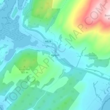
Nom : Carte topographique Appin, altitude, relief.

Lieu : Appin, Argyll and Bute, Scotland, PA38 4DB, United Kingdom (56.54179 -5.37849 56.58179 -5.33849)

Altitude moyenne : 93 m

Altitude minimum : -1 m

Altitude maximum : 461 m

Autres cartes topographiques

Cliquez sur une carte pour visualiser sa topographie, son altitude et son relief.

Mull

United Kingdom > Scotland > Argyll and Bute

Altitude moyenne : 122 m

Tiree

United Kingdom > Scotland > Argyll and Bute > Balemartine

Altitude moyenne : 3 m

Shuna

United Kingdom > Scotland > Argyll and Bute > Toberonochy

Altitude moyenne : 9 m

Islay

United Kingdom > Scotland > Argyll and Bute

Altitude moyenne : 53 m

Seil

United Kingdom > Scotland > Argyll and Bute > Clachan-Seil

Altitude moyenne : 16 m

Coll

United Kingdom > Scotland > Argyll and Bute > Arinagour

Altitude moyenne : 7 m

River Orchy

United Kingdom > Scotland > Argyll and Bute > Dalmally

Altitude moyenne : 353 m

River Laggan

United Kingdom > Scotland > Argyll and Bute

Altitude moyenne : 54 m

Loch Ba

United Kingdom > Scotland > Argyll and Bute

Altitude moyenne : 141 m

Sound of Mull

United Kingdom > Scotland > Argyll and Bute > Salen

Altitude moyenne : 134 m

Bowmore

United Kingdom > Scotland > Argyll and Bute

Altitude moyenne : 13 m

Staffa

United Kingdom > Scotland > Argyll and Bute

Altitude moyenne : 0 m

Kerrera

United Kingdom > Scotland > Argyll and Bute > Oban

Altitude moyenne : 34 m

Bute

United Kingdom > Scotland > Argyll and Bute > Ardbeg

Altitude moyenne : 41 m

Eilean Righ

United Kingdom > Scotland > Argyll and Bute

Altitude moyenne : 26 m

Colonsay

United Kingdom > Scotland > Argyll and Bute > Scalasaig

Altitude moyenne : 11 m

Craignure

United Kingdom > Scotland > Argyll and Bute

Altitude moyenne : 61 m

Awe Barrage

United Kingdom > Scotland > Argyll and Bute

Altitude moyenne : 263 m

Tobermory

United Kingdom > Scotland > Argyll and Bute

Altitude moyenne : 58 m

Tarbert

United Kingdom > Scotland > Argyll and Bute

Altitude moyenne : 69 m

Tobermory

United Kingdom > Scotland > Argyll and Bute

Altitude moyenne : 58 m

Loch Tulla

United Kingdom > Scotland > Argyll and Bute

Altitude moyenne : 210 m

Craignish

United Kingdom > Scotland > Argyll and Bute > Ardfern

Altitude moyenne : 36 m

Tobermory

United Kingdom > Scotland > Argyll and Bute

Altitude moyenne : 58 m

Loch Fyne

United Kingdom > Scotland > Argyll and Bute > Inveraray

Altitude moyenne : 137 m

Easdale

United Kingdom > Scotland > Argyll and Bute > Easdale

Altitude moyenne : 8 m

Lussa Loch

United Kingdom > Scotland > Argyll and Bute

Altitude moyenne : 191 m

Loch Gair

United Kingdom > Scotland > Argyll and Bute > Lochgair

Altitude moyenne : 44 m

Lismore

United Kingdom > Scotland > Argyll and Bute > Achnacroish

The island of Lismore lies in Loch Linnhe, north east of Mull, in the Argyll and Bute council area. It is 15 kilometres (9.3 mi) long and about 2 kilometres (1.2 mi) wide and oriented from SW to NE, roughly parallel to the Great Glen Fault. To the east is an arm of Loch Linnhe known as the Lynn of Lorn.…

Altitude moyenne : 16 m

Kilmartin

United Kingdom > Scotland > Argyll and Bute

Altitude moyenne : 112 m

Islay

United Kingdom > Scotland > Argyll and Bute

Altitude moyenne : 53 m

Tiree

United Kingdom > Scotland > Argyll and Bute > Scarinish

Altitude moyenne : 3 m

Tobermory

United Kingdom > Scotland > Argyll and Bute

Altitude moyenne : 58 m

Easdale

United Kingdom > Scotland > Argyll and Bute > Easdale

Altitude moyenne : 8 m

Loch Long

United Kingdom > Scotland > Argyll and Bute > Ardentinny

Altitude moyenne : 238 m

Bowmore

United Kingdom > Scotland > Argyll and Bute

Altitude moyenne : 13 m

Iona

United Kingdom > Scotland > Argyll and Bute > The Village

Altitude moyenne : 10 m

Staffa

United Kingdom > Scotland > Argyll and Bute

Altitude moyenne : 0 m

Islay

United Kingdom > Scotland > Argyll and Bute

Altitude moyenne : 53 m

Bowmore

United Kingdom > Scotland > Argyll and Bute

Altitude moyenne : 13 m

Staffa

United Kingdom > Scotland > Argyll and Bute

Altitude moyenne : 0 m

Loch Fyne

United Kingdom > Scotland > Argyll and Bute > Inveraray

Altitude moyenne : 137 m

Texa

United Kingdom > Scotland > Argyll and Bute

Altitude moyenne : 1 m

Loch Sloy

United Kingdom > Scotland > Argyll and Bute

Altitude moyenne : 479 m

Coll

United Kingdom > Scotland > Argyll and Bute > Arinagour

Altitude moyenne : 7 m

Loch Awe

United Kingdom > Scotland > Argyll and Bute > Lochawe

Altitude moyenne : 218 m

Merci de soutenir ce site ❤️
Faire un don

Équipez-vous pour votre prochaine aventure :

En tant que Partenaire Amazon, ce site perçoit une commission sur les achats éligibles sans surcoût pour vous.

Bute

United Kingdom > Scotland > Argyll and Bute > Kilchattan Bay

Altitude moyenne : 41 m

Loch Etive

United Kingdom > Scotland > Argyll and Bute > Connel

Altitude moyenne : 318 m

Cruachan Dam

United Kingdom > Scotland > Argyll and Bute

Altitude moyenne : 465 m

Loch Dochard

United Kingdom > Scotland > Argyll and Bute

Altitude moyenne : 318 m

Loch Etive

United Kingdom > Scotland > Argyll and Bute > Connel

Altitude moyenne : 318 m

Bute

United Kingdom > Scotland > Argyll and Bute > Ardbeg

Altitude moyenne : 41 m

Kilmartin

United Kingdom > Scotland > Argyll and Bute

Altitude moyenne : 112 m

Staffa

United Kingdom > Scotland > Argyll and Bute

Altitude moyenne : 0 m

Gigha

United Kingdom > Scotland > Argyll and Bute > Ardminish

Gigha lies 5 kilometres (3 mi) off the coast of Kintyre and is 9.5 km (6 mi) long in a roughly north-south direction and a maximum of 2.5 km (1 1⁄2 mi) wide. The total area is 1,395 hectares (3,450 acres) and the highest elevation of Creag Bhàn reaches only 100 m (330 ft). The rocky central spine is…

Altitude moyenne : 3 m

Torsa

United Kingdom > Scotland > Argyll and Bute > Ardinamir

Altitude moyenne : 12 m

Laggan Bay

United Kingdom > Scotland > Argyll and Bute

Altitude moyenne : 6 m

Iona

United Kingdom > Scotland > Argyll and Bute > The Village

Altitude moyenne : 9 m

Colonsay

United Kingdom > Scotland > Argyll and Bute > Scalasaig

Altitude moyenne : 11 m

Équipez-vous pour votre prochaine aventure :

🛠️Outils multifonctions - Réparations et usages polyvalents
🧤Sous-gants en soie - Apport de chaleur naturelle sans épaisseur supplémentaire
🧪Pastilles de purification - Rendez l'eau potable en toutes circonstances lors de vos expéditions
🛶Sacs étanches - Protection du matériel contre l’eau
🧱Matelas de camping - Matelas isolants pour nuits en plein air

En tant que Partenaire Amazon, ce site perçoit une commission sur les achats éligibles sans surcoût pour vous.