
Carte topographique Gigha
Cliquez sur la carte pour afficher l’altitude.
Gigha
Gigha lies 5 kilometres (3 mi) off the coast of Kintyre and is 9.5 km (6 mi) long in a roughly north-south direction and a maximum of 2.5 km (1 1⁄2 mi) wide. The total area is 1,395 hectares (3,450 acres) and the highest elevation of Creag Bhàn reaches only 100 m (330 ft). The rocky central spine is composed of epidiorite with basalt intrusions.
À propos de cette carte
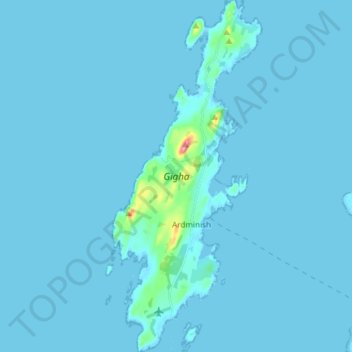
Nom : Carte topographique Gigha, altitude, relief.
Lieu : Gigha, Ardminish, Argyll and Bute, Scotland, United Kingdom (55.64568 -5.77448 55.72971 -5.71157)
Altitude moyenne : 3 m
Altitude minimum : -4 m
Altitude maximum : 94 m