Géolocaliser

Carte topographique Sundarnagar

Cliquez sur la carte pour afficher l’altitude.

À propos de cette carte

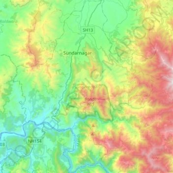
Nom : Carte topographique Sundarnagar, altitude, relief.

Lieu : Sundarnagar, Mandi, Himachal Pradesh, India (31.35065 76.78197 31.59126 77.00774)

Altitude moyenne : 1’207 m

Altitude minimum : 489 m

Altitude maximum : 2’760 m

Autres cartes topographiques

Cliquez sur une carte pour visualiser sa topographie, son altitude et son relief.

Dharamshala

India > Himachal Pradesh > Dharamshala

Dharamshala has an average elevation of 1,457 m (4,780 ft), covering an area of almost 8.51 km2 (3.29 sq mi). Dharamsala is located in the Kangra Valley, in the shadow of the Dhauladhar mountains.

Altitude moyenne : 1’781 m

Kangra

India > Himachal Pradesh

Altitude moyenne : 1’665 m

Shimla

India > Himachal Pradesh

Shimla is on the south-western ranges of the Himalayas at 31°37′N 77°06′E / 31.61°N 77.10°E / 31.61; 77.10. It has an average altitude of 2,206 metres (7,238 ft) above mean sea level and extends along a ridge with seven spurs. The city stretches nearly 9.2 kilometres (5.7 mi) from east to west.

Altitude moyenne : 1’557 m

Bambola

India > Himachal Pradesh > Mandi

Altitude moyenne : 2’156 m

Kullu

India > Himachal Pradesh > Kullu

Kullu town has an average elevation of 1,278 m (4,193 ft). It lies on the bank of Beas River.

Altitude moyenne : 1’808 m

Kasauli

India > Himachal Pradesh > Kasauli

Altitude moyenne : 1’255 m

Shangarh

India > Himachal Pradesh > Sainj

Altitude moyenne : 2’111 m

Thachi

India > Himachal Pradesh > Seoni

Altitude moyenne : 1’224 m

Jheol

India > Himachal Pradesh > Dharamshala

Altitude moyenne : 933 m

Bagi

India > Himachal Pradesh > Mandi

Altitude moyenne : 1’946 m

Mahasu

India > Himachal Pradesh > Shimla ( Rural ) > Kufri

Altitude moyenne : 2’382 m

Mahasu

India > Himachal Pradesh > Kotkhai

Altitude moyenne : 2’065 m

Neugal Rivulet

India > Himachal Pradesh > Palampur

Altitude moyenne : 1’019 m

Kangra Fort

India > Himachal Pradesh > Kangra > Kaswara

Altitude moyenne : 674 m

Bhattakufer

India > Himachal Pradesh > Shimla ( Rural )

Altitude moyenne : 1’951 m

Kachedh

India > Himachal Pradesh > Chaurah > Nakrod

Altitude moyenne : 1’515 m

Gugua

India > Himachal Pradesh > Chaurah > Khushnagri

Altitude moyenne : 1’914 m

Bagiyanda

India > Himachal Pradesh > Bhuntar > Jari

Altitude moyenne : 1’767 m

Khanola

India > Himachal Pradesh > Rohru > Bhot

Altitude moyenne : 2’147 m

Pandli

India > Himachal Pradesh > Kotkhai > Kotkhai

Altitude moyenne : 1’999 m

Merci de soutenir ce site ❤️
Faire un don

Équipez-vous pour votre prochaine aventure :

En tant que Partenaire Amazon, ce site perçoit une commission sur les achats éligibles sans surcoût pour vous.

Kalruhi

India > Himachal Pradesh > Amb

Altitude moyenne : 510 m

Aloh

India > Himachal Pradesh > Amb

Altitude moyenne : 677 m

Dalenu

India > Himachal Pradesh > Renuka

Altitude moyenne : 1’884 m

Killar

India > Himachal Pradesh > Pangi

Altitude moyenne : 2’691 m

Jadhana

India > Himachal Pradesh > Kandaghat

Altitude moyenne : 1’043 m

Swarka

India > Himachal Pradesh > Jogindarnagar > Sagnehad Haar

Altitude moyenne : 1’227 m

Pong Dam

India > Himachal Pradesh > Fatehpur

Altitude moyenne : 406 m

Tikri

India > Himachal Pradesh > Nermand > Kargar

Altitude moyenne : 1’898 m

Buner

India > Himachal Pradesh > Nagrota Bagwan

Altitude moyenne : 870 m

Dharamkot

India > Himachal Pradesh > Dharamshala

Altitude moyenne : 1’898 m

Bhutti

India > Himachal Pradesh > Kullu

Altitude moyenne : 1’912 m

Gopalpur

India > Himachal Pradesh > Sarkaghat

Altitude moyenne : 1’056 m

Tindi

India > Himachal Pradesh > Udaipur

Altitude moyenne : 2’984 m

Gushaini

India > Himachal Pradesh > Banjar

Altitude moyenne : 2’079 m

Pekhri

India > Himachal Pradesh > Banjar

Altitude moyenne : 2’192 m

Triund

India > Himachal Pradesh > Saluni

Altitude moyenne : 1’924 m

Gadheri

India > Himachal Pradesh > Seoni

Altitude moyenne : 1’630 m

Panog

India > Himachal Pradesh > Shimla ( Rural ) > Shogi

Altitude moyenne : 1’631 m

Solan

India > Himachal Pradesh > Solan

Solan is a city in the Indian state of Himachal Pradesh and the district headquarters of Solan district. It is located 45.5 kilometres (28 mi) south of the state capital, Shimla. Solan has an average elevation of 1,550 metres (5,090 ft). The city is situated between Chandigarh (joint capital of Punjab and…

Altitude moyenne : 1’312 m

Chintpurni

India > Himachal Pradesh > Dehra

Altitude moyenne : 799 m

Kinnu

India > Himachal Pradesh > Rampur

Altitude moyenne : 2’423 m

Daranghati WLS

India > Himachal Pradesh > Rampur > Kasha

Altitude moyenne : 3’565 m

Sarahan

India > Himachal Pradesh > Rampur

Sarahan is located at 31°31′N 77°48′E / 31.52°N 77.80°E / 31.52; 77.80. It has an average elevation of 2,313 metres (7,589 feet).

Altitude moyenne : 2’204 m

Rewalsar

India > Himachal Pradesh > Mandi

Rewalsar is located at an altitude of 1360 m above sea level. It is connected to Mandi by a motorable road and is about 25 km from Mandi. Lying in the Southern Himalayan belt, winters in Rewalsar can be freezing, while summers are generally pleasant.

Altitude moyenne : 1’283 m

Chakar

India > Himachal Pradesh > Shimla

Altitude moyenne : 1’796 m

Nagni

India > Himachal Pradesh > Dhira

Altitude moyenne : 768 m

Baghi

India > Himachal Pradesh > Kotkhai

Altitude moyenne : 2’576 m

Jarai

India > Himachal Pradesh > Chaupal > Maraug

Altitude moyenne : 2’348 m

Gumma

India > Himachal Pradesh > Kotkhai

Altitude moyenne : 1’807 m

Jabna

India > Himachal Pradesh > Chaupal

Altitude moyenne : 2’396 m

Kaffota

India > Himachal Pradesh > Kamrau

Altitude moyenne : 1’425 m

Hira

India > Himachal Pradesh > Cheta

Altitude moyenne : 1’764 m

Kaloha

India > Himachal Pradesh > Rakkar

Altitude moyenne : 732 m

Galma

India > Himachal Pradesh > Mandi

Altitude moyenne : 897 m

Rupin Pass

India > Himachal Pradesh > Dodra Kwar > Jiskon > Matiyam

Altitude moyenne : 4’564 m

Jorkanden

India > Himachal Pradesh > Moorang

Altitude moyenne : 5’506 m

Rahi

India > Himachal Pradesh > Bali Chowki > Balichowki

Altitude moyenne : 1’543 m

Dhaugi

India > Himachal Pradesh > Sainj

Altitude moyenne : 2’080 m

Garkhal

India > Himachal Pradesh > Kasauli

Altitude moyenne : 1’530 m

Keylang

India > Himachal Pradesh > Lahaul

Kyelang is accessible from Manali via the Manali-Leh Highway, a part of NH21. It is located about 71 km (44 mi) north of Manali at an altitude of 3,080 m (10,100 ft) and used to remain cut off from the outside world for six months from late October to mid-May due to heavy snowfall at Rohtang pass until the…

Altitude moyenne : 3’823 m

Arhal

India > Himachal Pradesh > Rohru

Altitude moyenne : 2’047 m

Sejar

India > Himachal Pradesh > Tikar

Altitude moyenne : 2’110 m

Utrala

India > Himachal Pradesh > Baijnath

Altitude moyenne : 1’517 m

Moti Tibba

India > Himachal Pradesh > Dalhousie > Dalhousie

Altitude moyenne : 1’773 m

Gajeha

India > Himachal Pradesh > Karsog

Altitude moyenne : 1’679 m

Teesa

India > Himachal Pradesh > Chaurah

Altitude moyenne : 1’872 m

Tosh

India > Himachal Pradesh > Bhuntar

Altitude moyenne : 2’726 m

Tawain

India > Himachal Pradesh > Pangi

Altitude moyenne : 3’154 m

Kharota

India > Himachal Pradesh > Dharamshala > Khaniara

Altitude moyenne : 1’713 m

Basantpur

India > Himachal Pradesh > Seoni

Altitude moyenne : 1’228 m

Dharot

India > Himachal Pradesh > Kumharsain

Altitude moyenne : 2’126 m

Kataula

India > Himachal Pradesh > Mandi

Altitude moyenne : 1’374 m

Gharoh

India > Himachal Pradesh > Dharamshala

Altitude moyenne : 1’029 m

Shahul

India > Himachal Pradesh > Sainj

Altitude moyenne : 1’648 m

Nani

India > Himachal Pradesh > Theog > Matiana

Altitude moyenne : 2’530 m

Kolhara

India > Himachal Pradesh > Jubbal > Jubbal

Altitude moyenne : 2’363 m

Fagu

India > Himachal Pradesh > Theog

Altitude moyenne : 2’223 m

Pin Valley National Park

India > Himachal Pradesh > Spiti

Altitude moyenne : 4’903 m

Bhojnagar

India > Himachal Pradesh > Solan

Altitude moyenne : 1’327 m

Darcha

India > Himachal Pradesh > Lahul

Darcha (elevation 3,360 m or 11,020 ft) is a pair of villages (Darcha Sumdo and Darach Dangma) on the Bhaga River in the Lahaul sub-division in the Lahaul and Spiti district in the Indian state of Himachal Pradesh. It is the northernmost permanent settlement in Himachal Pradesh along the Manali-Leh Highway.…

Altitude moyenne : 3’702 m

Dhamun

India > Himachal Pradesh > Shimla ( Rural )

Altitude moyenne : 1’353 m

Phancha

India > Himachal Pradesh > Rampur

Altitude moyenne : 2’472 m

Ganvi

India > Himachal Pradesh > Rampur

Altitude moyenne : 2’012 m

Racholi

India > Himachal Pradesh > Rampur > Khas Chati

Altitude moyenne : 1’554 m

Bhuthi

India > Himachal Pradesh > Karsog > Karsog

Altitude moyenne : 1’609 m

Kaza

India > Himachal Pradesh > Spiti

Kaza, also spelled Kaze, Karze, Karzey, is a town and the subdivisional headquarters of the remote Spiti Valley in the western Himalayas in the Lahaul and Spiti district of the northern Indian state of Himachal Pradesh. Spiti is a high altitude or cold desert having close similarities to the neighbouring Tibet…

Altitude moyenne : 4’161 m

Narghota

India > Himachal Pradesh > Dharamshala > Dharamshala

Altitude moyenne : 1’108 m

Shamshi Thach

India > Himachal Pradesh > Bhuntar

Altitude moyenne : 4’124 m

Shimla

India > Himachal Pradesh

Shimla is on the south-western ranges of the Himalayas at 31°37′N 77°06′E / 31.61°N 77.10°E / 31.61; 77.10. It has an average altitude of 2,206 metres (7,238 ft) above mean sea level and extends along a ridge with seven spurs. The city stretches nearly 9.2 kilometres (5+3⁄4 mi) from east to…

Altitude moyenne : 1’557 m

Kao

India > Himachal Pradesh > Brahmaur

Altitude moyenne : 2’552 m

Sugga

India > Himachal Pradesh > Rampur

Altitude moyenne : 2’170 m

Basadhar

India > Himachal Pradesh > Theog

Altitude moyenne : 1’863 m

Ranogi

India > Himachal Pradesh > Aut > Bandhi

Altitude moyenne : 2’195 m

Panjoh

India > Himachal Pradesh > Chamba > That

Altitude moyenne : 1’289 m

Phatt

India > Himachal Pradesh > Baijnath > Kotli

Altitude moyenne : 1’569 m

Sarkaghat

India > Himachal Pradesh > Sarkaghat

Altitude moyenne : 1’017 m

Basantpur

India > Himachal Pradesh > Seoni

Altitude moyenne : 1’228 m

Bhakra Dam

India > Himachal Pradesh > Bangana > Bilaspur

Altitude moyenne : 548 m

Kotli

India > Himachal Pradesh > Kotli

Kotli Tungal (Kotli) is a small town in Himachal Pradesh, in northern India located along national highway 70 (updated 003) which connects Jalandhar (in Punjab) to Mandi. It is 22 km (14 mi) from the town of Mandi, Kotli is a Sub Division and Tehsil (Sub District) of Mandi District. Kotli and the surrounding…

Altitude moyenne : 1’194 m

Dhala

India > Himachal Pradesh > Kumharsain

Altitude moyenne : 2’156 m

Équipez-vous pour votre prochaine aventure :

🧥Lessive pour vêtements techniques - Préservez l'imperméabilité de vos vestes haut de gamme
🛏️Sacs de couchage - Sacs de couchage adaptés à toutes saisons
💡Lanterne de tente - Éclairage d'ambiance pour vos soirées sous les étoiles
🧴Répulsifs anti-insectes - Protection contre moustiques et tiques
🧭Boussoles avec clinomètre - Orientation avancée

En tant que Partenaire Amazon, ce site perçoit une commission sur les achats éligibles sans surcoût pour vous.