
Carte topographique The Herring Pools (Low tide only)
Carte interactive
Cliquez sur la carte pour afficher l’altitude.
À propos de cette carte
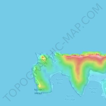
Nom : Carte topographique The Herring Pools (Low tide only), altitude, relief.
Altitude moyenne : 12 m
Altitude minimum : -1 m
Altitude maximum : 178 m
Autres cartes topographiques
Cliquez sur une carte pour visualiser sa topographie, son altitude et son relief.
Lord Howe Island
Australia > New South Wales > Lord Howe Island
Lord Howe Island, New South Wales, 2898, Australia
Altitude moyenne : 27 m
Mount Gower
Australia > New South Wales > Lord Howe Island
Mount Gower, Lord Howe Island, New South Wales, 2898, Australia
Altitude moyenne : 120 m