
Carte topographique Oregon
Carte interactive
Cliquez sur la carte pour afficher l’altitude.
À propos de cette carte
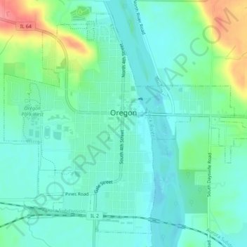
Nom : Carte topographique Oregon, altitude, relief.
Altitude moyenne : 223 m
Altitude minimum : 202 m
Altitude maximum : 285 m
Autres cartes topographiques
Cliquez sur une carte pour visualiser sa topographie, son altitude et son relief.
Grand Detour
United States > Illinois > Ogle County
Grand Detour, Grand Detour Township, Ogle County, Illinois, United States
Altitude moyenne : 213 m
Stillman Valley
United States > Illinois > Ogle County
Stillman Valley, Marion Township, Ogle County, Illinois, United States
Altitude moyenne : 222 m
Rockvale Township
United States > Illinois > Ogle County
Rockvale Township, Ogle County, Illinois, United States
Altitude moyenne : 239 m
Lost Nation
United States > Illinois > Ogle County
Lost Nation, Taylor Township, Ogle County, Illinois, United States
Altitude moyenne : 223 m
Leaf River
United States > Illinois > Ogle County
Leaf River, Leaf River Township, Ogle County, Illinois, United States
Altitude moyenne : 227 m
Monroe Township
United States > Illinois > Ogle County
Monroe Township, Ogle County, Illinois, 61052, United States
Altitude moyenne : 243 m
Byron
United States > Illinois > Ogle County > Byron
Byron, Ogle County, Illinois, 61010, United States
Altitude moyenne : 226 m
Monroe Center
United States > Illinois > Ogle County
Monroe Center, Monroe Township, Ogle County, Illinois, United States
Altitude moyenne : 254 m
Rochelle
United States > Illinois > Ogle County
Rochelle, Flagg Township, Ogle County, Illinois, 61068, United States
Altitude moyenne : 243 m