
Carte topographique Byron
Carte interactive
Cliquez sur la carte pour afficher l’altitude.
À propos de cette carte
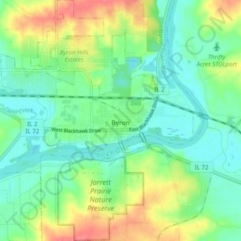
Nom : Carte topographique Byron, altitude, relief.
Lieu : Byron, Ogle County, Illinois, 61010, United States (42.10210 -89.28963 42.15265 -89.23507)
Altitude moyenne : 226 m
Altitude minimum : 204 m
Altitude maximum : 267 m
Byron is located in Byron Township at the junction of Illinois Route 72 and Illinois Route 2. Byron's topography includes a man-made prairie and the Rock River that passes through the town. It is generally flat and is ideal for farming in most regions. According to the 2010 census, Byron has a total area of 3.572 square miles (9.25 km2), of which 3.57 square miles (9.25 km2) (or 99.94%) is land and 0.002 square miles (0.01 km2) (or 0.06%) is water.