
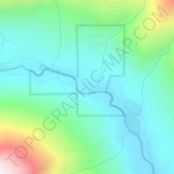
Carte topographique Icicle Creek
Carte interactive
Cliquez sur la carte pour afficher l’altitude.
À propos de cette carte
Nom : Carte topographique Icicle Creek, altitude, relief.
Lieu : Icicle Creek, Chelan County, Washington, United States (47.60279 -120.83066 47.60498 -120.82382)
Altitude moyenne : 974 m
Altitude minimum : 723 m
Altitude maximum : 1’763 m
Autres cartes topographiques
Cliquez sur une carte pour visualiser sa topographie, son altitude et son relief.
Entiat
United States > Washington > Chelan County
Entiat, Chelan County, Washington, United States
Altitude moyenne : 376 m
Lake Wenatchee
United States > Washington > Chelan County
Lake Wenatchee, Chelan County, Washington, United States
Altitude moyenne : 874 m
Dark Peak
United States > Washington > Chelan County
Dark Peak, Chelan County, Washington, United States
Altitude moyenne : 2’058 m
Plain
United States > Washington > Chelan County
Plain, Chelan County, Washington, United States
Altitude moyenne : 673 m
Dragontail Peak
United States > Washington > Chelan County
Dragontail Peak, Chelan County, Washington, United States
Altitude moyenne : 2’235 m
Copper Peak
United States > Washington > Chelan County
Copper Peak, Chelan County, Washington, United States
Altitude moyenne : 2’032 m
Labyrinth Mountain
United States > Washington > Chelan County
Labyrinth Mountain, Chelan County, Washington, United States
Altitude moyenne : 1’514 m
Bear Lake
United States > Washington > Chelan County
Bear Lake, Chelan County, Washington, United States
Altitude moyenne : 1’855 m
Wenatchee
United States > Washington > Chelan County
Wenatchee, Chelan County, Washington, 98801, United States
Altitude moyenne : 302 m
Sahale Glacier
United States > Washington > Chelan County
Sahale Glacier, Chelan County, Washington, United States
Altitude moyenne : 2’062 m