
Carte topographique Dragontail Peak
Carte interactive
Cliquez sur la carte pour afficher l’altitude.
À propos de cette carte
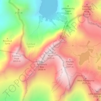
Nom : Carte topographique Dragontail Peak, altitude, relief.
Lieu : Dragontail Peak, Chelan County, Washington, United States (47.47898 -120.83298 47.47908 -120.83288)
Altitude moyenne : 2’235 m
Altitude minimum : 1’689 m
Altitude maximum : 2’662 m
The Alpine Lakes Wilderness features some of the most rugged topography in the Cascade Range with craggy peaks and ridges, deep glacial valleys, and granite walls spotted with over 700 mountain lakes. Geological events occurring many years ago created the diverse topography and drastic elevation changes over the Cascade Range leading to the various climate differences.
Autres cartes topographiques
Cliquez sur une carte pour visualiser sa topographie, son altitude et son relief.
Entiat
United States > Washington > Chelan County
Entiat, Chelan County, Washington, United States
Altitude moyenne : 376 m
Lake Wenatchee
United States > Washington > Chelan County
Lake Wenatchee, Chelan County, Washington, United States
Altitude moyenne : 874 m
Dark Peak
United States > Washington > Chelan County
Dark Peak, Chelan County, Washington, United States
Altitude moyenne : 2’058 m
Plain
United States > Washington > Chelan County
Plain, Chelan County, Washington, United States
Altitude moyenne : 673 m
Copper Peak
United States > Washington > Chelan County
Copper Peak, Chelan County, Washington, United States
Altitude moyenne : 2’032 m
Icicle Creek
United States > Washington > Chelan County
Icicle Creek, Chelan County, Washington, United States
Altitude moyenne : 974 m
Labyrinth Mountain
United States > Washington > Chelan County
Labyrinth Mountain, Chelan County, Washington, United States
Altitude moyenne : 1’514 m
Bear Lake
United States > Washington > Chelan County
Bear Lake, Chelan County, Washington, United States
Altitude moyenne : 1’855 m
Wenatchee
United States > Washington > Chelan County
Wenatchee, Chelan County, Washington, 98801, United States
Altitude moyenne : 302 m
Sahale Glacier
United States > Washington > Chelan County
Sahale Glacier, Chelan County, Washington, United States
Altitude moyenne : 2’062 m