
Carte topographique Old Stone Fort State Archaeological Park
Carte interactive
Cliquez sur la carte pour afficher l’altitude.
À propos de cette carte
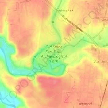
Nom : Carte topographique Old Stone Fort State Archaeological Park, altitude, relief.
Altitude moyenne : 316 m
Altitude minimum : 268 m
Altitude maximum : 339 m
The Duck River system spills over a limestone-rich shelf of the western Cumberland Plateau known as the Highland Rim. As the Duck and Little Duck approach their convergence, they rapidly drop in elevation, and have cut relatively deep gorges around the peninsula upon which the ancient structure is located. Both gorges are highlighted by a series of substantial waterfalls and whitewater rapids. The natural waterpower in these two gorges attracted entrepreneurs and millwrights throughout the 19th century.
Autres cartes topographiques
Cliquez sur une carte pour visualiser sa topographie, son altitude et son relief.
Glenview
United States > Tennessee > Coffee County > Manchester
Glenview, Manchester, Coffee County, Middle Tennessee, Tennessee, 37355, United States
Altitude moyenne : 322 m
White Oaks
United States > Tennessee > Coffee County > Manchester
White Oaks, Manchester, Coffee County, Tennessee, 38505, United States
Altitude moyenne : 325 m
Belmont
United States > Tennessee > Coffee County > Manchester
Belmont, Manchester, Coffee County, Middle Tennessee, Tennessee, United States
Altitude moyenne : 320 m
Royal Oaks
United States > Tennessee > Coffee County > Manchester > Royal Oaks
Royal Oaks, Manchester, Coffee County, Tennessee, 38505, United States
Altitude moyenne : 326 m
Westwood
United States > Tennessee > Coffee County > Manchester > Westwood
Westwood, Manchester, Coffee County, Tennessee, 37183:37355, United States
Altitude moyenne : 322 m