Géolocaliser

Carte topographique Junction Hill

Cliquez sur la carte pour afficher l’altitude.

À propos de cette carte

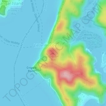
Nom : Carte topographique Junction Hill, altitude, relief.

Lieu : Junction Hill, Central Coast Council, New South Wales, 2083, Australia (-33.55148 151.25254 -33.55138 151.25264)

Altitude moyenne : 33 m

Altitude minimum : -3 m

Altitude maximum : 166 m

Autres cartes topographiques

Cliquez sur une carte pour visualiser sa topographie, son altitude et son relief.

Sydney

Australia > New South Wales

Sydney's topography is characterized by a diverse landscape that seamlessly blends coastal features with inland plateaus. The city is divided into two primary regions: the relatively flat Cumberland Plain to the south and west of Sydney Harbour, and the elevated Hornsby Plateau to the north. The Cumberland…

Altitude moyenne : 53 m

Edmondson Park

Australia > New South Wales > Sydney

Altitude moyenne : 56 m

Newcastle

Australia > New South Wales

Altitude moyenne : 5 m

Sydney

Australia > New South Wales > Sydney

Altitude moyenne : 23 m

Katoomba

Australia > New South Wales

Altitude moyenne : 904 m

Glen Innes

Australia > New South Wales

Altitude moyenne : 1’083 m

Penrith

Australia > New South Wales > Sydney > Penrith

Penrith is a city in New South Wales, Australia, located in Greater Western Sydney, 55 kilometres (31 mi) west of the Sydney central business district on the banks of the Nepean River, on the outskirts of the Cumberland Plain. Its elevation is 32 metres (105 ft).

Altitude moyenne : 34 m

Chatswood

Australia > New South Wales

Altitude moyenne : 81 m

Gulmarrad

Australia > New South Wales

Altitude moyenne : 10 m

Lismore

Australia > New South Wales

Altitude moyenne : 23 m

Cooranbong

Australia > New South Wales

Altitude moyenne : 72 m

Bowral

Australia > New South Wales

Altitude moyenne : 690 m

Moss Vale

Australia > New South Wales

Altitude moyenne : 673 m

Wardell

Australia > New South Wales

Altitude moyenne : 10 m

Eastern Creek

Australia > New South Wales

Altitude moyenne : 60 m

Armidale

Australia > New South Wales

Altitude moyenne : 1’036 m

Byron Bay

Australia > New South Wales

Byron Bay, located in northeastern New South Wales, Australia, is characterized by diverse topography shaped by its geological history. The town is part of the erosion caldera of the ancient Tweed Volcano, which erupted approximately 23 million years ago, resulting in the rich volcanic soils that define the…

Altitude moyenne : 7 m

Baulkham Hills

Australia > New South Wales

Altitude moyenne : 93 m

Robertson

Australia > New South Wales

Altitude moyenne : 545 m

Swansea

Australia > New South Wales

Altitude moyenne : 7 m

Vaucluse

Australia > New South Wales > Sydney

Altitude moyenne : 20 m

Pitt Town

Australia > New South Wales

Altitude moyenne : 19 m

Banora Point

Australia > New South Wales

Altitude moyenne : 17 m

Orange

Australia > New South Wales

Orange is a city in the Central Tablelands region of New South Wales, Australia. It is 254 km (158 mi) west of the state capital, Sydney [206 km (128 mi) on a great circle], at an altitude of 862 metres (2,828 ft). Orange had an estimated urban population of 40,493 as of June 2018 making the city a significant…

Altitude moyenne : 852 m

Northern Beaches

Australia > New South Wales > Sydney

Altitude moyenne : 67 m

Waverley

Australia > New South Wales > Sydney

Waverley Council takes its name from the suburb but its administrative centre is located in the adjacent suburb of Bondi Junction, which is also a major commercial centre. Waverley is the highest point of altitude in Sydney's Eastern Suburbs.

Altitude moyenne : 60 m

Mulbring

Australia > New South Wales

Altitude moyenne : 96 m

Blowering Dam

Australia > New South Wales > Blowering

Altitude moyenne : 405 m

Berry

Australia > New South Wales

Altitude moyenne : 38 m

Rock Valley

Australia > New South Wales

Altitude moyenne : 92 m

Goulburn

Australia > New South Wales

Owing to its elevation, Goulburn has an oceanic climate (Cfb) with warm summers and cool winters; with a high diurnal range. Its climate is variable much of the year, though generally dry with maximum temperatures ranging from 11.8 °C (53.2 °F) in July to 28.3 °C (82.9 °F) in January. Rainfall is…

Altitude moyenne : 666 m

Port Macquarie

Australia > New South Wales

Altitude moyenne : 5 m

Rutherford

Australia > New South Wales

Altitude moyenne : 23 m

Medlow Bath

Australia > New South Wales

Medlow Bath (postcode: 2780) is an Australian small town located near the highest point of the Blue Mountains, between Katoomba and Blackheath. Its altitude is about 1,050 metres (3,440 ft) AHD  and it is about 115 kilometres (71 mi) west-north-west of the Sydney central business district and 5 kilometres…

Altitude moyenne : 930 m

Bangalow

Australia > New South Wales

Altitude moyenne : 83 m

South Grafton

Australia > New South Wales

Altitude moyenne : 36 m

Berridale

Australia > New South Wales

Altitude moyenne : 936 m

Hornsby

Australia > New South Wales > Sydney

Altitude moyenne : 160 m

Kingscliff

Australia > New South Wales

Altitude moyenne : 5 m

Gorokan

Australia > New South Wales

Altitude moyenne : 7 m

Sanctuary Point

Australia > New South Wales

Altitude moyenne : 10 m

Yamba

Australia > New South Wales

Altitude moyenne : 2 m

Portland

Australia > New South Wales

At an altitude of 925 metres above sea level, Portland is the 21st highest town in Australia and classified as a temperate zone. Cool winters and warm summers ensure four distinct seasons and snowfalls each winter.

Altitude moyenne : 972 m

Jiggi

Australia > New South Wales

Altitude moyenne : 105 m

Pearl Beach

Australia > New South Wales

Altitude moyenne : 34 m

Dalgety

Australia > New South Wales

Altitude moyenne : 866 m

Kings Forest

Australia > New South Wales

Altitude moyenne : 13 m

Federation Council

Australia > New South Wales

Altitude moyenne : 143 m

Grafton

Australia > New South Wales

Altitude moyenne : 5 m

Smiths Creek

Australia > New South Wales

Altitude moyenne : 99 m

Ulladulla

Australia > New South Wales

Altitude moyenne : 21 m

Central Coast Council

Australia > New South Wales

Altitude moyenne : 103 m

Geehi

Australia > New South Wales

Altitude moyenne : 1’019 m

Yass

Australia > New South Wales

Yass is located 280 km south-west of Sydney, on the Hume Highway. The Yass River, which is a tributary of the Murrumbidgee River, flows through the town. Yass is 59 km from Canberra; lying at an elevation of 505 m AMSL.

Altitude moyenne : 533 m

Mudgee

Australia > New South Wales

Altitude moyenne : 535 m

Newtown

Australia > New South Wales > Sydney

Altitude moyenne : 22 m

Asquith

Australia > New South Wales

Altitude moyenne : 168 m

Primrose Valley

Australia > New South Wales

Altitude moyenne : 843 m

Minnamurra River

Australia > New South Wales

Altitude moyenne : 8 m

Wagga Wagga

Australia > New South Wales

Altitude moyenne : 183 m

Comboyne

Australia > New South Wales

Altitude moyenne : 435 m

Farrants Hill

Australia > New South Wales

Altitude moyenne : 54 m

Bawley Point

Australia > New South Wales

Altitude moyenne : 17 m

Iluka

Australia > New South Wales

Altitude moyenne : 2 m

St Leonards

Australia > New South Wales > Sydney

Altitude moyenne : 69 m

Darlinghurst

Australia > New South Wales > Sydney

Altitude moyenne : 38 m

Scotts Head

Australia > New South Wales

Altitude moyenne : 5 m

Rozelle

Australia > New South Wales > Sydney

Altitude moyenne : 16 m

Woy Woy

Australia > New South Wales

Altitude moyenne : 35 m

Casino

Australia > New South Wales

Altitude moyenne : 32 m

St Ives

Australia > New South Wales

Altitude moyenne : 125 m

Leura

Australia > New South Wales

Leura's elevation of 985 metres (3,232 ft) AHD  leads to occasional snowfall in winter and a climate that reflects all four seasons distinctly.

Altitude moyenne : 880 m

Umina Beach

Australia > New South Wales

Altitude moyenne : 38 m

Kariong

Australia > New South Wales > Gosford

Altitude moyenne : 86 m

Murwillumbah

Australia > New South Wales

Altitude moyenne : 7 m

Coogee

Australia > New South Wales

Altitude moyenne : 35 m

Wauchope

Australia > New South Wales

Altitude moyenne : 32 m

Ocean Shores

Australia > New South Wales

Altitude moyenne : 12 m

Panania

Australia > New South Wales > Sydney

Altitude moyenne : 17 m

Bundeena

Australia > New South Wales > Sydney

Altitude moyenne : 20 m

Bywong

Australia > New South Wales

Altitude moyenne : 734 m

North Nowra

Australia > New South Wales

Altitude moyenne : 33 m

Kiama

Australia > New South Wales

Altitude moyenne : 29 m

Patonga

Australia > New South Wales

Altitude moyenne : 53 m

New England National Park

Australia > New South Wales

The park lies within the Eastern Australian temperate forests ecoregion. It is noted for the wide variety of plant and animal species. The diverse vegetation in the park includes sub-tropical, warm temperate and cool temperate rainforest in the higher altitudes. There are also areas of sclerophyll forest,…

Altitude moyenne : 559 m

Longneck Lagoon

Australia > New South Wales > Sydney

Altitude moyenne : 21 m

Équipez-vous pour votre prochaine aventure :

🪖Casques vélo et VTT - Protection en terrain accidenté
Piquets de tente légers - Solidité et légèreté pour remplacer vos piquets d'origine
🧭Boussole de précision - Idéale pour l'orientation avec cartes topographiques en milieu alpin
🏕️Tentes de randonnée - Tentes légères pour bivouac et trekking
🔦Lampe frontale LED - Éclairage mains libres indispensable pour les départs à l'aube

En tant que Partenaire Amazon, ce site perçoit une commission sur les achats éligibles sans surcoût pour vous.