
Carte topographique Burnley
Carte interactive
Cliquez sur la carte pour afficher l’altitude.
À propos de cette carte
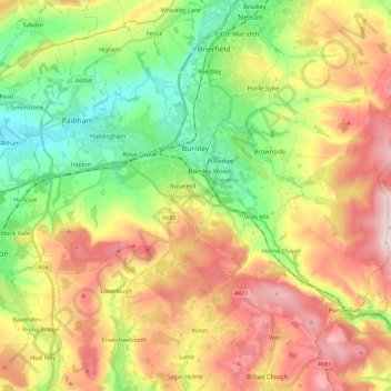
Nom : Carte topographique Burnley, altitude, relief.
Lieu : Burnley, Lancashire, England, United Kingdom (53.72300 -2.34231 53.82526 -2.11228)
Altitude moyenne : 247 m
Altitude minimum : 63 m
Altitude maximum : 479 m
The town lies in a natural three-forked valley at the confluence of the River Brun and the River Calder, surrounded by open fields, with wild moorland at higher altitudes. To the west of Burnley lie the towns of Padiham, Accrington and Blackburn, with Nelson and Colne to the north. The centre of the town stands at approximately 387 feet (118 m) above sea level and 30 miles (48 km) east of the Irish Sea coast.
Autres cartes topographiques
Cliquez sur une carte pour visualiser sa topographie, son altitude et son relief.
Waddington
United Kingdom > England > Lancashire > Ribble Valley
Waddington, Ribble Valley, Lancashire, England, United Kingdom
Altitude moyenne : 164 m
Great Eccleston
United Kingdom > England > Lancashire > Borough of Wyre
Great Eccleston, Borough of Wyre, Lancashire, England, United Kingdom
Altitude moyenne : 12 m
Wymott
United Kingdom > England > Lancashire > Chorley
Wymott, Ulnes Walton, Chorley, Lancashire, England, PR26 8NH, United Kingdom
Altitude moyenne : 17 m
Croston
United Kingdom > England > Lancashire > Chorley
Croston, Chorley, Lancashire, England, United Kingdom
Altitude moyenne : 8 m
Fleetwood
United Kingdom > England > Lancashire > Borough of Wyre
Fleetwood, Borough of Wyre, Lancashire, England, United Kingdom
Altitude moyenne : 2 m
Leyland
United Kingdom > England > Lancashire > South Ribble
Leyland, South Ribble, Lancashire, England, PR25 2EX, United Kingdom
Altitude moyenne : 41 m
Read
United Kingdom > England > Lancashire > Ribble Valley
Read, Ribble Valley, Lancashire, England, United Kingdom
Altitude moyenne : 114 m
Lytham St Annes
United Kingdom > England > Lancashire > Fylde > Lytham St Annes
Lytham St Annes, Fylde, Lancashire, North West England, England, FY8 4AR, United Kingdom
Altitude moyenne : 5 m
Jamacia Wood
United Kingdom > England > Lancashire > Ribble Valley > Langho
Jamacia Wood, Billington and Langho, Langho, Ribble Valley, Lancashire, England, United Kingdom
Altitude moyenne : 100 m