
Carte topographique Waddington
Carte interactive
Cliquez sur la carte pour afficher l’altitude.
À propos de cette carte
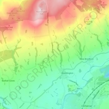
Nom : Carte topographique Waddington, altitude, relief.
Lieu : Waddington, Ribble Valley, Lancashire, England, United Kingdom (53.86998 -2.43837 53.92913 -2.39235)
Altitude moyenne : 164 m
Altitude minimum : 18 m
Altitude maximum : 392 m
Autres cartes topographiques
Cliquez sur une carte pour visualiser sa topographie, son altitude et son relief.
Read
United Kingdom > England > Lancashire > Ribble Valley
Read, Ribble Valley, Lancashire, England, United Kingdom
Altitude moyenne : 114 m
Jamacia Wood
United Kingdom > England > Lancashire > Ribble Valley > Langho
Jamacia Wood, Billington and Langho, Langho, Ribble Valley, Lancashire, England, United Kingdom
Altitude moyenne : 100 m