
Carte topographique Collin County
Cliquez sur la carte pour afficher l’altitude.
À propos de cette carte
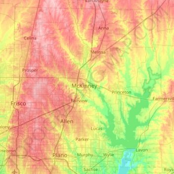
Nom : Carte topographique Collin County, altitude, relief.
Lieu : Collin County, Texas, United States (32.98150 -96.84413 33.40548 -96.29535)
Altitude moyenne : 191 m
Altitude minimum : 131 m
Altitude maximum : 252 m
Autres cartes topographiques
Cliquez sur une carte pour visualiser sa topographie, son altitude et son relief.
Georgetown
United States > Texas > Georgetown
The city is located on the northeastern edge of Texas Hill Country. Portions of Georgetown are located on either side of the Balcones Escarpment, a fault line in which the areas roughly east of IH-35 are flat and characterized by having black, fertile soils of the Blackland Prairie, and the west side of the…
Altitude moyenne : 219 m
Enchanted Rock
United States > Texas > Llano County
Enchanted Rock is a pink granite mountain located in the Llano Uplift about 17 miles (27 km) north of Fredericksburg, Texas and 24 miles (39 km) south of Llano, Texas, United States. Enchanted Rock State Natural Area, which includes Enchanted Rock and surrounding land, spans the border between Gillespie and…
Altitude moyenne : 453 m
Padre Island National Seashore
United States > Texas > Kenedy County > Corpus Christi
Altitude moyenne : 5 m
Choke Canyon State Park - Calliham Unit
United States > Texas > McMullen County > Calliham
Altitude moyenne : 67 m
Mineral Wells Fossil Park
United States > Texas > Palo Pinto County > Mineral Wells
Altitude moyenne : 283 m
Rio Vista Addition Colonia
United States > Texas > El Paso County > Socorro
Altitude moyenne : 1’116 m