
Carte topographique Greenwood
Carte interactive
Cliquez sur la carte pour afficher l’altitude.
À propos de cette carte
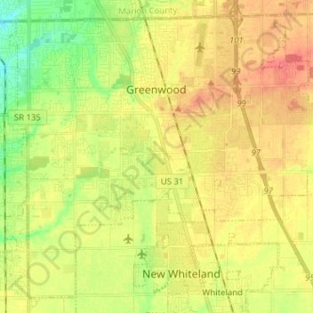
Nom : Carte topographique Greenwood, altitude, relief.
Lieu : Greenwood, Johnson County, Indiana, United States (39.54837 -86.16704 39.63693 -86.04000)
Altitude moyenne : 245 m
Altitude minimum : 216 m
Altitude maximum : 270 m
Greenwood's mean elevation is 813 feet (248 m) above sea level. The city's topography is flat to gently rolling.
Autres cartes topographiques
Cliquez sur une carte pour visualiser sa topographie, son altitude et son relief.
Nineveh
United States > Indiana > Johnson County
Nineveh, Johnson County, Indiana, United States
Altitude moyenne : 238 m
Trafalgar
United States > Indiana > Johnson County
Trafalgar, Johnson County, Indiana, United States
Altitude moyenne : 257 m
Bargersville
United States > Indiana > Johnson County
Bargersville, Johnson County, Indiana, 46106, United States
Altitude moyenne : 243 m
Edinburgh
United States > Indiana > Johnson County
Edinburgh, Johnson County, Indiana, United States
Altitude moyenne : 205 m
Stones Crossing
United States > Indiana > Johnson County > Greenwood
Stones Crossing, Greenwood, Johnson County, Indiana, 46143, United States
Altitude moyenne : 238 m
Green Valley
United States > Indiana > Johnson County > Greenwood
Green Valley, Greenwood, Johnson County, Indiana, 46143, United States
Altitude moyenne : 239 m
Franklin
United States > Indiana > Johnson County
Franklin, Johnson County, Indiana, 46131, United States
Altitude moyenne : 230 m