
Carte topographique Bargersville
Carte interactive
Cliquez sur la carte pour afficher l’altitude.
À propos de cette carte
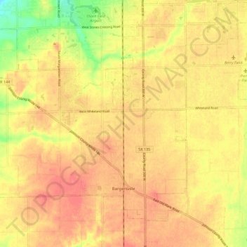
Nom : Carte topographique Bargersville, altitude, relief.
Lieu : Bargersville, Johnson County, Indiana, 46106, United States (39.50955 -86.25076 39.57762 -86.13911)
Altitude moyenne : 243 m
Altitude minimum : 203 m
Altitude maximum : 262 m
Autres cartes topographiques
Cliquez sur une carte pour visualiser sa topographie, son altitude et son relief.
Nineveh
United States > Indiana > Johnson County
Nineveh, Johnson County, Indiana, United States
Altitude moyenne : 238 m
Trafalgar
United States > Indiana > Johnson County
Trafalgar, Johnson County, Indiana, United States
Altitude moyenne : 257 m
Greenwood
United States > Indiana > Johnson County
Greenwood, Johnson County, Indiana, United States
Altitude moyenne : 245 m
Edinburgh
United States > Indiana > Johnson County
Edinburgh, Johnson County, Indiana, United States
Altitude moyenne : 205 m
Stones Crossing
United States > Indiana > Johnson County > Greenwood
Stones Crossing, Greenwood, Johnson County, Indiana, 46143, United States
Altitude moyenne : 238 m
Green Valley
United States > Indiana > Johnson County > Greenwood
Green Valley, Greenwood, Johnson County, Indiana, 46143, United States
Altitude moyenne : 239 m
Franklin
United States > Indiana > Johnson County
Franklin, Johnson County, Indiana, 46131, United States
Altitude moyenne : 230 m