
Carte topographique Ball Ground
Carte interactive
Cliquez sur la carte pour afficher l’altitude.
À propos de cette carte
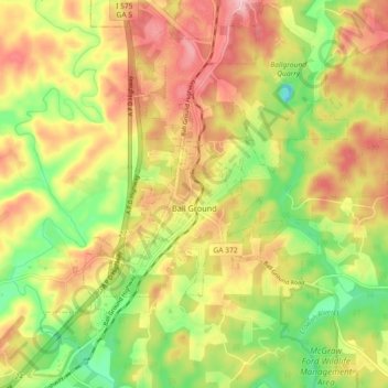
Nom : Carte topographique Ball Ground, altitude, relief.
Lieu : Ball Ground, Cherokee County, Georgia, United States (34.31118 -84.41254 34.37075 -84.32178)
Altitude moyenne : 331 m
Altitude minimum : 243 m
Altitude maximum : 414 m
According to the United States Census Bureau as of 2020, Ball Ground has a total area of 6.3 sq mi (16 km2), of which 0.04 sq mi (0.10 km2), or 0.63%, is water. The city's elevation averages around 1,100 ft (340 m) above sea level, ranging from just over 1,000 ft (300 m) in the valleys to around 1,200 ft (370 m) on several hilltops within the city. Unlike most other parts of Cherokee County, Ball Ground is not in a floodplain and has no typically flood prone areas. To protect the water and surrounding lands, the city government has ordinances in place for stream buffer protection, watershed protection, and wetland protection.
Autres cartes topographiques
Cliquez sur une carte pour visualiser sa topographie, son altitude et son relief.
Canton
United States > Georgia > Cherokee County
Canton, Cherokee County, Georgia, United States
Altitude moyenne : 320 m
Woodstock
United States > Georgia > Cherokee County
Woodstock, Cherokee County, Georgia, United States
Altitude moyenne : 296 m
Worley Crossroads
United States > Georgia > Cherokee County
Worley Crossroads, Cherokee County, Georgia, United States
Altitude moyenne : 378 m
Bear Mountain
United States > Georgia > Cherokee County
Bear Mountain, Cherokee County, Georgia, United States
Altitude moyenne : 497 m
Hickory Flat
United States > Georgia > Cherokee County
Hickory Flat, Cherokee County, Georgia, 30115, United States
Altitude moyenne : 307 m
Burris Crossroads
United States > Georgia > Cherokee County
Burris Crossroads, Cherokee County, Georgia, United States
Altitude moyenne : 386 m
Waleska
United States > Georgia > Cherokee County
Waleska, Cherokee County, Georgia, United States
Altitude moyenne : 335 m
Ophir
United States > Georgia > Cherokee County
Ophir, Cherokee County, Georgia, United States
Altitude moyenne : 341 m
Ball Ground
United States > Georgia > Cherokee County > Ball Ground
Ball Ground, Cherokee County, Georgia, 30107, United States
Altitude moyenne : 332 m
Holly Springs
United States > Georgia > Cherokee County
Holly Springs, Cherokee County, Georgia, United States
Altitude moyenne : 306 m
Beck Lake
United States > Georgia > Cherokee County
Beck Lake, Cherokee County, Georgia, United States
Altitude moyenne : 341 m
Free Home
United States > Georgia > Cherokee County
Free Home, Cherokee County, Georgia, 30155, United States
Altitude moyenne : 360 m