Carte topographique Nocatee
Cliquez sur la carte pour afficher l’altitude.
À propos de cette carte
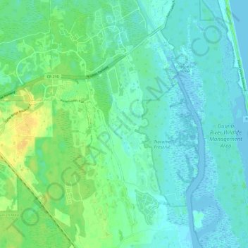
Nom : Carte topographique Nocatee, altitude, relief.
Lieu : Nocatee, Saint Johns County, Florida, 32081, United States (30.04711 -81.48076 30.14394 -81.36572)
Altitude moyenne : 7 m
Altitude minimum : -5 m
Altitude maximum : 22 m
Autres cartes topographiques
Cliquez sur une carte pour visualiser sa topographie, son altitude et son relief.

Ponte Vedra Beach
United States > Florida > Saint Johns County > Ponte Vedra Beach
Ponte Vedra Beach is characterized by its gently rolling terrain that is primarily flat and lies only about 15 feet above sea level. The landscape is predominantly shaped by coastal dunes and the proximity to the Atlantic Ocean, resulting in sandy beaches interspersed with vegetation typical of barrier island…
Altitude moyenne : 3 m
Anastasia Island
United States > Florida > Saint Johns County > St. Augustine South
Altitude moyenne : 4 m




Butler Beach
United States > Florida > Saint Johns County > Saint Augustine Beach
Altitude moyenne : 3 m


Butler Beach
United States > Florida > Saint Johns County > Saint Augustine Beach
Altitude moyenne : 2 m



Butler Beach
United States > Florida > Saint Johns County > Saint Augustine Beach
Altitude moyenne : 3 m

Ponte Vedra Beach
United States > Florida > Saint Johns County > Ponte Vedra Beach
Altitude moyenne : 3 m
Anastasia Island
United States > Florida > Saint Johns County > Saint Augustine
Altitude moyenne : 4 m
Fort Peyton
United States > Florida > Saint Johns County > St. Augustine South
Altitude moyenne : 11 m