
Carte topographique Eagle Nest WLS
Carte interactive
Cliquez sur la carte pour afficher l’altitude.
À propos de cette carte
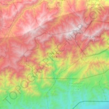
Nom : Carte topographique Eagle Nest WLS, altitude, relief.
Altitude moyenne : 1’680 m
Altitude minimum : 149 m
Altitude maximum : 3’247 m
Autres cartes topographiques
Cliquez sur une carte pour visualiser sa topographie, son altitude et son relief.
Bhalukpong
India > Arunachal Pradesh > Bhalukpong EAC
Bhalukpong, Bhalukpong EAC, West Kameng District, Arunachal Pradesh, 790114, India
Altitude moyenne : 243 m
Sessa Orchid Sanctuary
India > Arunachal Pradesh > Bhalukpong EAC
Sessa Orchid Sanctuary, Doimara-Nichiphu, Bhalukpong EAC, West Kameng district, Arunachal Pradesh, 784147, India
Altitude moyenne : 1’414 m