
Carte topographique Kabul Province
Carte interactive
Cliquez sur la carte pour afficher l’altitude.
À propos de cette carte
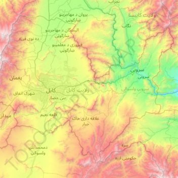
Nom : Carte topographique Kabul Province, altitude, relief.
Lieu : Kabul Province, Afghanistan (34.14516 68.83353 34.90711 69.94387)
Altitude moyenne : 2’166 m
Altitude minimum : 804 m
Altitude maximum : 4’727 m
Autres cartes topographiques
Cliquez sur une carte pour visualiser sa topographie, son altitude et son relief.
Bagrami
Afghanistan > Kabul Province > Bagrami District
Bagrami, Bagrami District, Kabul Province, Afghanistan
Altitude moyenne : 1’801 m
Kabul District
Kabul District, Kabul Province, Afghanistan
Altitude moyenne : 1’968 m
Kabul
Afghanistan > Kabul Province > Kabul District
Kabul, Kabul District, Kabul Province, 1001, Afghanistan
Altitude moyenne : 1’945 m
Paghman
Afghanistan > Kabul Province > Paghman
Paghman, Kabul Province, Afghanistan
Altitude moyenne : 2’606 m
Surobi
Afghanistan > Kabul Province > Surobi > Surobi
Surobi, Kabul Province, Afghanistan
Altitude moyenne : 1’520 m
Chashmah-ye Masti
Afghanistan > Kabul Province > Surobi > Chashmah-ye Masti
Chashmah-ye Masti, Surobi, Kabul Province, Afghanistan
Altitude moyenne : 1’425 m
Shakardara
Shakardara, Kabul Province, 1061, Afghanistan
Altitude moyenne : 2’281 m