
Carte topographique Saratoga County
Carte interactive
Cliquez sur la carte pour afficher l’altitude.
À propos de cette carte
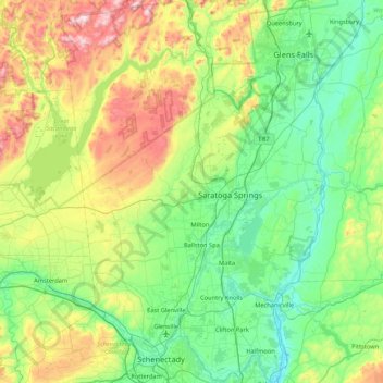
Nom : Carte topographique Saratoga County, altitude, relief.
Lieu : Saratoga County, New York, United States of America (42.77546 -74.16010 43.39797 -73.57327)
Altitude moyenne : 218 m
Altitude minimum : 3 m
Altitude maximum : 833 m
Saratoga County is situated in the eastern portion of New York, north of Albany, northwest of Troy, and east of Utica. According to the U.S. Census Bureau, the county has a total area of 844 square miles (2,190 km2), of which 810 square miles (2,100 km2) are land and 34 square miles (88 km2) (4.0%) are covered by water. The Hudson River forms the eastern border of the county, while the Mohawk River demarcates its southern border. The highest elevation in Saratoga County is at the peak of Tennet Mountain in the Adirondack Mountains, at 2,759 ft (841 m), while the lowest elevation is 69 ft (21 m), at the waterfront of the Village of Waterford, at the confluence of the Mohawk and Hudson Rivers.
Autres cartes topographiques
Cliquez sur une carte pour visualiser sa topographie, son altitude et son relief.
Ulster
United States of America > New York
Ulster, New York, United States of America
Altitude moyenne : 343 m
Saint Lawrence
United States of America > New York
Saint Lawrence, New York, United States of America
Altitude moyenne : 239 m
Chenango County
United States of America > New York
Chenango County, New York, United States of America
Altitude moyenne : 442 m
Parish
United States of America > New York > Parish
Parish, Town of Parish, Oswego County, New York, 13131, United States of America
Altitude moyenne : 147 m
Essex County
United States of America > New York
Essex County, New York, United States of America
Altitude moyenne : 418 m
Chautauqua County
United States of America > New York
Chautauqua County, New York, United States of America
Altitude moyenne : 328 m
Town of Onondaga
United States of America > New York
Town of Onondaga, Onondaga County, New York, 13215, United States of America
Altitude moyenne : 266 m
Westchester
United States of America > New York
Westchester, New York, United States of America
Altitude moyenne : 95 m
Farmingville
United States of America > New York > Farmingville
Farmingville, Suffolk County, New York, 11738, United States of America
Altitude moyenne : 47 m