
Carte topographique Ulster
Carte interactive
Cliquez sur la carte pour afficher l’altitude.
À propos de cette carte
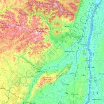
Nom : Carte topographique Ulster, altitude, relief.
Lieu : Ulster, New York, United States of America (41.58061 -74.78113 42.17699 -73.91155)
Altitude moyenne : 343 m
Altitude minimum : -6 m
Altitude maximum : 1’259 m
Autres cartes topographiques
Cliquez sur une carte pour visualiser sa topographie, son altitude et son relief.
Saint Lawrence
United States of America > New York
Saint Lawrence, New York, United States of America
Altitude moyenne : 239 m
Chenango County
United States of America > New York
Chenango County, New York, United States of America
Altitude moyenne : 442 m
Parish
United States of America > New York > Parish
Parish, Town of Parish, Oswego County, New York, 13131, United States of America
Altitude moyenne : 147 m
Town of Onondaga
United States of America > New York
Town of Onondaga, Onondaga County, New York, 13215, United States of America
Altitude moyenne : 266 m
Essex County
United States of America > New York
Essex County, New York, United States of America
Altitude moyenne : 418 m
Chautauqua County
United States of America > New York
Chautauqua County, New York, United States of America
Altitude moyenne : 328 m
Westchester
United States of America > New York
Westchester, New York, United States of America
Altitude moyenne : 95 m
Farmingville
United States of America > New York > Farmingville
Farmingville, Suffolk County, New York, 11738, United States of America
Altitude moyenne : 47 m
Saratoga County
United States of America > New York
Saratoga County, New York, United States of America
Altitude moyenne : 218 m
Niagara Falls
United States of America > New York > Niagara Falls
Niagara Falls, Niagara County, New York, United States of America
Altitude moyenne : 180 m
Suffolk County
United States of America > New York
Suffolk County, New York, United States of America
Altitude moyenne : 36 m