
Faire un don
Équipez-vous pour votre prochaine aventure :
En tant que Partenaire Amazon, ce site perçoit une commission sur les achats éligibles sans surcoût pour vous.
Carte topographique Cairngorm Mountains
Cliquez sur la carte pour afficher l’altitude.
Faire un don
Équipez-vous pour votre prochaine aventure :
En tant que Partenaire Amazon, ce site perçoit une commission sur les achats éligibles sans surcoût pour vous.
Cairngorm Mountains
In terms of height, remoteness and the severe and changeable weather, the Cairngorms are the most arduous area in the United Kingdom. The plateau area has a Tundra climate (Köppen ET), and the shattered terrain is more like the high ground in high-arctic Canada or northern Norway than what is often observed in the European Alps or Rockies. The weather often deteriorates rapidly with altitude so that, when there are moderate conditions 150 m (490 ft) below the plateau, the top can be stormy or misty, and there can be icy or powdery snow. Even when no snow is falling, the wind can whip up lying snow to produce white-out conditions for a few metres above the surface, and snowdrifts can build up rapidly in sheltered places. Gravel can be blown through the air, and walking can be impossible.
Faire un don
Équipez-vous pour votre prochaine aventure :
En tant que Partenaire Amazon, ce site perçoit une commission sur les achats éligibles sans surcoût pour vous.
À propos de cette carte
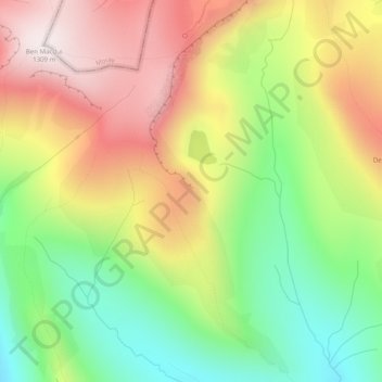
Nom : Carte topographique Cairngorm Mountains, altitude, relief.
Lieu : Cairngorm Mountains, Aberdeenshire, Scotland, United Kingdom (57.05995 -3.65005 57.06005 -3.64995)
Altitude moyenne : 937 m
Altitude minimum : 592 m
Altitude maximum : 1’312 m
Faire un don
Équipez-vous pour votre prochaine aventure :
En tant que Partenaire Amazon, ce site perçoit une commission sur les achats éligibles sans surcoût pour vous.
Autres cartes topographiques
Cliquez sur une carte pour visualiser sa topographie, son altitude et son relief.
Faire un don
Équipez-vous pour votre prochaine aventure :
En tant que Partenaire Amazon, ce site perçoit une commission sur les achats éligibles sans surcoût pour vous.
Dunnottar Castle
United Kingdom > Scotland > Aberdeenshire > Stonehaven > Mains of Dunnottar
Altitude moyenne : 33 m
Faire un don
Équipez-vous pour votre prochaine aventure :
En tant que Partenaire Amazon, ce site perçoit une commission sur les achats éligibles sans surcoût pour vous.
Faire un don
Équipez-vous pour votre prochaine aventure :
En tant que Partenaire Amazon, ce site perçoit une commission sur les achats éligibles sans surcoût pour vous.
Cairngorm Mountains
United Kingdom > Scotland > Aberdeenshire
In terms of height, remoteness and the severe and changeable weather, the Cairngorms are the most arduous area in the United Kingdom. The plateau area has a Tundra climate (Köppen ET), and the shattered terrain is more like the high ground in high-arctic Canada or northern Norway than what is often observed…
Altitude moyenne : 619 m
Faire un don
Équipez-vous pour votre prochaine aventure :
En tant que Partenaire Amazon, ce site perçoit une commission sur les achats éligibles sans surcoût pour vous.
Glen Tanar
United Kingdom > Scotland > Aberdeenshire > Aboyne
Glen Tanar, along with the side glens formed by the Water of Gairney and the Water of Allachy, comprises the third largest area of Caledonian Forest in Scotland, which grows from the valley floor up to an altitude of 450 metres. As a Caledonian Forest, the predominant tree species is Scots pine, although…
Altitude moyenne : 389 m
Faire un don
Équipez-vous pour votre prochaine aventure :
En tant que Partenaire Amazon, ce site perçoit une commission sur les achats éligibles sans surcoût pour vous.
Faire un don
Équipez-vous pour votre prochaine aventure :
En tant que Partenaire Amazon, ce site perçoit une commission sur les achats éligibles sans surcoût pour vous.