
Faire un don
Équipez-vous pour votre prochaine aventure :
En tant que Partenaire Amazon, ce site perçoit une commission sur les achats éligibles sans surcoût pour vous.
Carte topographique Glen Tanar
Cliquez sur la carte pour afficher l’altitude.
Faire un don
Équipez-vous pour votre prochaine aventure :
En tant que Partenaire Amazon, ce site perçoit une commission sur les achats éligibles sans surcoût pour vous.
Glen Tanar
Glen Tanar, along with the side glens formed by the Water of Gairney and the Water of Allachy, comprises the third largest area of Caledonian Forest in Scotland, which grows from the valley floor up to an altitude of 450 metres. As a Caledonian Forest, the predominant tree species is Scots pine, although broad-leaved tree species including birch, alder, rowan, holly, aspen and oak are also present. Juniper grows at the boundary between the forest and the open moorland above, and areas of blaeberry, heather and feather mosses can also be found. the woodland floor provides a habitat for many of the species typically found in the Caledonian Forest, including twinflower, creeping lady's-tresses, toothed wintergreen and intermediate wintergreen.
Faire un don
Équipez-vous pour votre prochaine aventure :
En tant que Partenaire Amazon, ce site perçoit une commission sur les achats éligibles sans surcoût pour vous.
À propos de cette carte
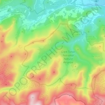
Nom : Carte topographique Glen Tanar, altitude, relief.
Altitude moyenne : 389 m
Altitude minimum : 132 m
Altitude maximum : 821 m
Faire un don
Équipez-vous pour votre prochaine aventure :
En tant que Partenaire Amazon, ce site perçoit une commission sur les achats éligibles sans surcoût pour vous.