
Carte topographique Liphook
Cliquez sur la carte pour afficher l’altitude.
Liphook
In Samuel Lewis's 1831 Topographical Dictionary of England, he referred to Liphook as a hamlet in the parish of Bramshott.
À propos de cette carte
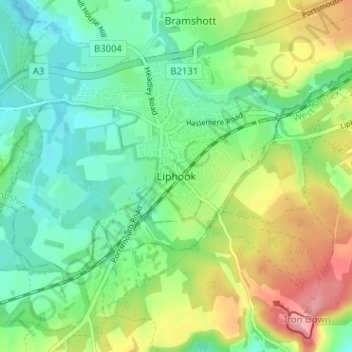
Nom : Carte topographique Liphook, altitude, relief.
Altitude moyenne : 121 m
Altitude minimum : 80 m
Altitude maximum : 196 m
Autres cartes topographiques
Cliquez sur une carte pour visualiser sa topographie, son altitude et son relief.
Rowlands Castle
United Kingdom > England > Hampshire > East Hampshire > Finchdean
Altitude moyenne : 72 m
Four Marks
United Kingdom > England > Hampshire > East Hampshire > Four Marks
Altitude moyenne : 185 m
Rowland's Copse, Red Hill
United Kingdom > England > Hampshire > East Hampshire > Rowlands Castle
Altitude moyenne : 42 m
Newton Valence
United Kingdom > England > Hampshire > East Hampshire
The village sits high in the westernmost chalk hills of the South Downs: maximum elevation 191 metres (627 feet) above sea level. Much of the surrounding landscape is within the East Hampshire Area of Outstanding Natural Beauty.
Altitude moyenne : 153 m
Comp
United Kingdom > England > Hampshire > East Hampshire > Upper Farringdon
Altitude moyenne : 126 m
Bramshott Common
United Kingdom > England > Hampshire > East Hampshire > Bramshott
Altitude moyenne : 148 m
Havant Thicket
United Kingdom > England > Hampshire > East Hampshire > Rowlands Castle
Altitude moyenne : 48 m
Ludshott Common
United Kingdom > England > Hampshire > East Hampshire > Bramshott
Altitude moyenne : 162 m
Farringdon
United Kingdom > England > Hampshire > East Hampshire > Lower Farringdon
Altitude moyenne : 153 m
Ditcham Woods.
United Kingdom > England > Hampshire > East Hampshire > Buriton
Altitude moyenne : 136 m
Shalden
United Kingdom > England > Hampshire > East Hampshire
Shalden is a village and civil parish in the East Hampshire district of Hampshire, England. It is 2.3 miles (3.7 km) northwest of Alton and 1.9 miles (3.1 km) northeast of Bentworth, just off the A339 road. The parish covers an area of 1,536 acres (622 ha) and has an average elevation of 600 feet (180 m) above…
Altitude moyenne : 177 m
Queen Elizabeth Country Park
United Kingdom > England > Hampshire > East Hampshire > Buriton
Altitude moyenne : 151 m
Medstead
United Kingdom > England > Hampshire > East Hampshire
Medstead is a village and civil parish in the East Hampshire district of Hampshire, England. Its nearest town is Alton, which lies 4.3 miles (6.9 km) northeast of the village. According to the 2011 census, the village had a population of 2,036 people. The parish covers an area of 1,536 acres (622 ha) and has…
Altitude moyenne : 186 m
East Tisted
United Kingdom > England > Hampshire > East Hampshire > East Tisted
Altitude moyenne : 171 m
Medstead
United Kingdom > England > Hampshire > East Hampshire
Medstead is a village and civil parish in the East Hampshire district of Hampshire, England. Its nearest town is Alton, which lies 4.3 miles (6.9 km) northeast of the village. According to the 2011 census, the village had a population of 2,036 people. The parish covers an area of 1,536 acres (622 ha) and has…
Altitude moyenne : 186 m
Rowlands Castle
United Kingdom > England > Hampshire > East Hampshire > Finchdean
Altitude moyenne : 72 m